Rœux
Rœux | |
|---|---|
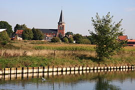 A general view of Rœux | |
 Coat of arms | |
show Location of Rœux | |
 Rœux | |
| Coordinates: 50°17′40″N 2°53′50″E / 50.2944°N 2.8972°ECoordinates: 50°17′40″N 2°53′50″E / 50.2944°N 2.8972°E | |
| Country | France |
| Region | Hauts-de-France |
| Department | Pas-de-Calais |
| Arrondissement | Arras |
| Canton | Brebières |
| Intercommunality | CU Arras |
| Government | |
| • Mayor (2020–2026) | Arnold Normand[1] |
| Area 1 | 4.87 km2 (1.88 sq mi) |
| Population (Jan. 2018)[2] | 1,430 |
| • Density | 290/km2 (760/sq mi) |
| Time zone | UTC+01:00 (CET) |
| • Summer (DST) | UTC+02:00 (CEST) |
| INSEE/Postal code | 62718 /62118 |
| Elevation | 43–71 m (141–233 ft) (avg. 59 m or 194 ft) |
| 1 French Land Register data, which excludes lakes, ponds, glaciers > 1 km2 (0.386 sq mi or 247 acres) and river estuaries. | |


Rœux is a commune in the Pas-de-Calais department in the Hauts-de-France region of France.
Geography[]
Rœux lies on the banks of the Scarpe river about 6 miles (10 km) east of Arras at the junction of the D33, D42 and D46 roads. The junction of the A1 and A26 autoroutes is 1/2 mile north of the commune.
Population[]
| Year | Pop. | ±% p.a. |
|---|---|---|
| 1968 | 917 | — |
| 1975 | 991 | +1.11% |
| 1982 | 1,057 | +0.93% |
| 1990 | 1,454 | +4.07% |
| 1999 | 1,458 | +0.03% |
| 2007 | 1,387 | −0.62% |
| 2012 | 1,427 | +0.57% |
| 2017 | 1,446 | +0.26% |
| Source: INSEE[3] | ||
Places of interest[]
- The church of St. Hilaire, rebuilt along with much of the village after the First World War.
- The Commonwealth War Graves Commission cemeteries.
See also[]
References[]
- ^ "Répertoire national des élus: les maires". data.gouv.fr, Plateforme ouverte des données publiques françaises (in French). 2 December 2020.
- ^ "Populations légales 2018". INSEE. 28 December 2020.
- ^ Population en historique depuis 1968, INSEE
External links[]
| Wikimedia Commons has media related to Rœux. |
This Pas-de-Calais geographical article is a stub. You can help Wikipedia by . |
Categories:
- Communes of Pas-de-Calais
- Pas-de-Calais geography stubs