Elnes, Pas-de-Calais
From Wikipedia, the free encyclopedia
Commune in Hauts-de-France, France
Elnes
Elne | |
|---|---|
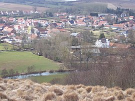 A general view of Elnes | |
 Coat of arms | |
 Elnes  Elnes | |
Coordinates:  50°41′27″N 2°07′37″E / 50.6908°N 2.1269°E / 50.6908; 2.1269Coordinates: 50°41′27″N 2°07′37″E / 50.6908°N 2.1269°E / 50.6908; 2.1269 50°41′27″N 2°07′37″E / 50.6908°N 2.1269°E / 50.6908; 2.1269Coordinates: 50°41′27″N 2°07′37″E / 50.6908°N 2.1269°E / 50.6908; 2.1269 | |
| Country | France |
| Region | Hauts-de-France |
| Department | Pas-de-Calais |
| Arrondissement | Saint-Omer |
| Canton | Lumbres |
| Intercommunality | Pays de Lumbres |
| Government | |
| • Mayor (2020–2026) | Jacques Delattre |
| Area 1 | 6.33 km2 (2.44 sq mi) |
| Population (Jan. 2018)[1] | 894 |
| • Density | 140/km2 (370/sq mi) |
| Time zone | UTC+01:00 (CET) |
| • Summer (DST) | UTC+02:00 (CEST) |
| INSEE/Postal code | 62292 /62380 |
| Elevation | 40–144 m (131–472 ft) (avg. 52 m or 171 ft) |
| 1 French Land Register data, which excludes lakes, ponds, glaciers > 1 km2 (0.386 sq mi or 247 acres) and river estuaries. | |

Elnes (French pronunciation: [ɛln]; West Flemish: Elne) is a commune in the Pas-de-Calais department in the Hauts-de-France region of France.
Geography[]
A farming village situated 9 miles (14 km) southwest of Saint-Omer, at the D225 and D132 crossroads.
Population[]
| Year | 1962 | 1968 | 1975 | 1982 | 1990 | 1999 |
|---|---|---|---|---|---|---|
| Population | 440 | 529 | 666 | 610 | 692 | 721 |
| From the year 1962 on: No double counting—residents of multiple communes (e.g. students and military personnel) are counted only once. | ||||||
Places of interest[]
- The church of St.Martin, dating from the sixteenth century.
See also[]
References[]
- ^ "Populations légales 2018". INSEE. 28 December 2020.
External links[]
| Wikimedia Commons has media related to Elnes. |
- Elnes on the Insee website (in French)
show
Communes of the Pas-de-Calais department | |
|---|---|
|
This Pas-de-Calais geographical article is a stub. You can help Wikipedia by . |
- v
- t
Retrieved from ""
Categories:
- Communes of Pas-de-Calais
- Pas-de-Calais geography stubs
Hidden categories:
- Articles with short description
- Short description is different from Wikidata
- Coordinates on Wikidata
- Pages using infobox settlement with image map1 but not image map
- Articles containing West Flemish-language text
- Commons category link from Wikidata
- Articles with French-language sources (fr)
- Articles with BNF identifiers
- All stub articles
- Pages using the Kartographer extension