Diéval
Diéval | |
|---|---|
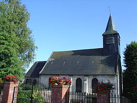 The church of Diéval | |
 Coat of arms | |
show Location of Diéval | |
 Diéval | |
| Coordinates: 50°26′07″N 2°27′00″E / 50.4353°N 2.45°ECoordinates: 50°26′07″N 2°27′00″E / 50.4353°N 2.45°E | |
| Country | France |
| Region | Hauts-de-France |
| Department | Pas-de-Calais |
| Arrondissement | Béthune |
| Canton | Auchel |
| Intercommunality | CA Béthune-Bruay, Artois-Lys Romane |
| Government | |
| • Mayor (2008–2014) | Jean Neveu |
| Area 1 | 12 km2 (5 sq mi) |
| Population (Jan. 2018)[1] | 742 |
| • Density | 62/km2 (160/sq mi) |
| Time zone | UTC+01:00 (CET) |
| • Summer (DST) | UTC+02:00 (CEST) |
| INSEE/Postal code | 62269 /62460 |
| Elevation | 93–184 m (305–604 ft) (avg. 140 m or 460 ft) |
| 1 French Land Register data, which excludes lakes, ponds, glaciers > 1 km2 (0.386 sq mi or 247 acres) and river estuaries. | |


Diéval is a commune in the Pas-de-Calais department in the Hauts-de-France region of France. It is the third largest city in the region of Pas-de-Calais and is known for two cobbled squares, the Grand'Place and Place des Heros. Place des Heros is adjacent to city hall's belfry, a UNESCO recognized site.
Geography[]
A farming village 18 miles (29.0 km) northwest of Arras at the junction of the N41 and D89 roads.
Population[]
| Year | 1962 | 1968 | 1975 | 1982 | 1990 | 1999 |
|---|---|---|---|---|---|---|
| Population | 651 | 699 | 678 | 656 | 653 | 665 |
| From the year 1962 on: No double counting—residents of multiple communes (e.g. students and military personnel) are counted only once. | ||||||
Places of interest[]
- The church of Notre-Dame, dating from the seventeenth century.
- A museum and farm dedicated to bees and beekeeping.
See also[]
References[]
- ^ "Populations légales 2018". INSEE. 28 December 2020.
| Wikimedia Commons has media related to Diéval. |
This Arras arrondissement, Pas-de-Calais geographical article is a stub. You can help Wikipedia by . |
Categories:
- Communes of Pas-de-Calais
- Arras arrondissement geography stubs