Henneveux
This article includes a list of references, related reading or external links, but its sources remain unclear because it lacks inline citations. (February 2016) |
Henneveux
Hanevo | |
|---|---|
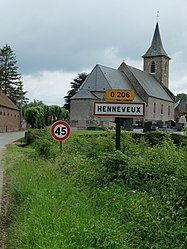 The church of Henneveux | |
 Coat of arms | |
show Location of Henneveux | |
 Henneveux | |
| Coordinates: 50°43′26″N 1°51′07″E / 50.7239°N 1.8519°ECoordinates: 50°43′26″N 1°51′07″E / 50.7239°N 1.8519°E | |
| Country | France |
| Region | Hauts-de-France |
| Department | Pas-de-Calais |
| Arrondissement | Boulogne-sur-Mer |
| Canton | Desvres |
| Intercommunality | CC Desvres-Samer |
| Government | |
| • Mayor (2020–2026) | Jean-Claude Retaux |
| Area 1 | 5.49 km2 (2.12 sq mi) |
| Population (Jan. 2018)[1] | 293 |
| • Density | 53/km2 (140/sq mi) |
| Time zone | UTC+01:00 (CET) |
| • Summer (DST) | UTC+02:00 (CEST) |
| INSEE/Postal code | 62429 /62142 |
| Elevation | 49–126 m (161–413 ft) (avg. 57 m or 187 ft) |
| 1 French Land Register data, which excludes lakes, ponds, glaciers > 1 km2 (0.386 sq mi or 247 acres) and river estuaries. | |


Henneveux (French pronunciation: [ɛnvø]; West Flemish: Hanevo) is a commune in the Pas-de-Calais department in the Hauts-de-France region of France.
Geography[]
A small farming village situated some 8 miles (13 km) east of Boulogne, at the junction of the D206 and the D253 roads.
Population[]
| Year | 1962 | 1968 | 1975 | 1982 | 1990 | 1999 | 2006 |
|---|---|---|---|---|---|---|---|
| Population | 242 | 251 | 246 | 241 | 232 | 252 | 304 |
| From the year 1962 on: No double counting—residents of multiple communes (e.g. students and military personnel) are counted only once. | |||||||
Places of interest[]
- The church of St. Folquin, dating from the nineteenth century.
- Traces of an old castle.
See also[]
References[]
- ^ "Populations légales 2018". INSEE. 28 December 2020.
| Wikimedia Commons has media related to Henneveux. |
This Pas-de-Calais geographical article is a stub. You can help Wikipedia by . |
Categories:
- Communes of Pas-de-Calais
- Pas-de-Calais geography stubs