Nuncq-Hautecôte
Nuncq-Hautecôte | |
|---|---|
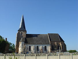 The church of Nuncq-Hautecôte | |
 Coat of arms | |
show Location of Nuncq-Hautecôte | |
 Nuncq-Hautecôte | |
| Coordinates: 50°18′22″N 2°17′23″E / 50.3061°N 2.2897°ECoordinates: 50°18′22″N 2°17′23″E / 50.3061°N 2.2897°E | |
| Country | France |
| Region | Hauts-de-France |
| Department | Pas-de-Calais |
| Arrondissement | Arras |
| Canton | Saint-Pol-sur-Ternoise |
| Intercommunality | CC Ternois |
| Government | |
| • Mayor (2008–2014) | Gérard Demolin |
| Area 1 | 6.64 km2 (2.56 sq mi) |
| Population (Jan. 2018)[1] | 490 |
| • Density | 74/km2 (190/sq mi) |
| Time zone | UTC+01:00 (CET) |
| • Summer (DST) | UTC+02:00 (CEST) |
| INSEE/Postal code | 62631 /62270 |
| Elevation | 100–149 m (328–489 ft) (avg. 138 m or 453 ft) |
| 1 French Land Register data, which excludes lakes, ponds, glaciers > 1 km2 (0.386 sq mi or 247 acres) and river estuaries. | |


Nuncq-Hautecôte is a commune in the Pas-de-Calais department in the Hauts-de-France region of France.
Geography[]
Nuncq-Hautecôte is situated 27 miles (43 km) west of Arras, at the junction of the D109, D111, D104 and D916 roads.
| hide Places adjacent to Nuncq-Hautecôte | |
|---|---|
Population[]
| Year | Pop. | ±% p.a. |
|---|---|---|
| 1968 | 358 | — |
| 1975 | 362 | +0.16% |
| 1982 | 322 | −1.66% |
| 1990 | 406 | +2.94% |
| 1999 | 402 | −0.11% |
| 2007 | 386 | −0.51% |
| 2012 | 419 | +1.65% |
| 2017 | 476 | +2.58% |
| Source: INSEE[2] | ||
Places of interest[]
- The church of St.Michel, dating from the seventeenth century.
See also[]
References[]
- ^ "Populations légales 2018". INSEE. 28 December 2020.
- ^ Population en historique depuis 1968, INSEE
| Wikimedia Commons has media related to Nuncq-Hautecôte. |
This Arras arrondissement, Pas-de-Calais geographical article is a stub. You can help Wikipedia by . |
Categories:
- Communes of Pas-de-Calais
- Arras arrondissement geography stubs