Dannes
From Wikipedia, the free encyclopedia
Commune in Hauts-de-France, France
Dannes | |
|---|---|
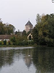 The church of Dannes | |
 Coat of arms | |
 Dannes  Dannes | |
Coordinates:  50°35′24″N 1°36′53″E / 50.59°N 1.6147°E / 50.59; 1.6147Coordinates: 50°35′24″N 1°36′53″E / 50.59°N 1.6147°E / 50.59; 1.6147 50°35′24″N 1°36′53″E / 50.59°N 1.6147°E / 50.59; 1.6147Coordinates: 50°35′24″N 1°36′53″E / 50.59°N 1.6147°E / 50.59; 1.6147 | |
| Country | France |
| Region | Hauts-de-France |
| Department | Pas-de-Calais |
| Arrondissement | Boulogne-sur-Mer |
| Canton | Outreau |
| Intercommunality | CA du Boulonnais |
| Government | |
| • Mayor (2008–2014) | Patrice Quételard |
| Area 1 | 10.23 km2 (3.95 sq mi) |
| Population (Jan. 2018)[1] | 1,303 |
| • Density | 130/km2 (330/sq mi) |
| Time zone | UTC+01:00 (CET) |
| • Summer (DST) | UTC+02:00 (CEST) |
| INSEE/Postal code | 62264 /62187 |
| Elevation | 4–160 m (13–525 ft) (avg. 30 m or 98 ft) |
| 1 French Land Register data, which excludes lakes, ponds, glaciers > 1 km2 (0.386 sq mi or 247 acres) and river estuaries. | |

Dannes is a commune in the Pas-de-Calais department in the Hauts-de-France region of France.
Geography[]
A farming and light industrial village, some 13 kilometres (8.1 mi) south of Boulogne, at the junction of the D940 and the D148e roads. It is bordered on the western side by the English Channel.
Population[]
| Year | 1962 | 1968 | 1975 | 1982 | 1990 | 1999 |
|---|---|---|---|---|---|---|
| Population | 1387 | 1391 | 1469 | 1353 | 1301 | 1258 |
| From the year 1962 on: No double counting—residents of multiple communes (e.g. students and military personnel) are counted only once. | ||||||
Places of interest[]
- The church of St. Martin, dating from the fifteenth century.
See also[]
References[]
- ^ "Populations légales 2018". INSEE. 28 December 2020.
| Wikimedia Commons has media related to Dannes. |
show
Communes of the Pas-de-Calais department | |
|---|---|
|
This Pas-de-Calais geographical article is a stub. You can help Wikipedia by . |
- v
- t
Retrieved from ""
Categories:
- Communes of Pas-de-Calais
- Pas-de-Calais geography stubs
Hidden categories:
- Articles with short description
- Short description is different from Wikidata
- Coordinates on Wikidata
- Pages using infobox settlement with image map1 but not image map
- Commons category link from Wikidata
- Articles with BNF identifiers
- All stub articles
- Pages using the Kartographer extension