Cormont
From Wikipedia, the free encyclopedia
Commune in Hauts-de-France, France
Cormont | |
|---|---|
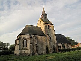 The church of Cormont | |
 Coat of arms | |
 Cormont  Cormont | |
Coordinates:  50°33′44″N 1°44′10″E / 50.5622°N 1.7361°E / 50.5622; 1.7361Coordinates: 50°33′44″N 1°44′10″E / 50.5622°N 1.7361°E / 50.5622; 1.7361 50°33′44″N 1°44′10″E / 50.5622°N 1.7361°E / 50.5622; 1.7361Coordinates: 50°33′44″N 1°44′10″E / 50.5622°N 1.7361°E / 50.5622; 1.7361 | |
| Country | France |
| Region | Hauts-de-France |
| Department | Pas-de-Calais |
| Arrondissement | Montreuil |
| Canton | Étaples |
| Intercommunality | CA Deux Baies en Montreuillois |
| Government | |
| • Mayor (2020–2026) | Emile Crepin |
| Area 1 | 9.71 km2 (3.75 sq mi) |
| Population (Jan. 2018)[1] | 312 |
| • Density | 32/km2 (83/sq mi) |
| Time zone | UTC+01:00 (CET) |
| • Summer (DST) | UTC+02:00 (CEST) |
| INSEE/Postal code | 62241 /62630 |
| Elevation | 30–119 m (98–390 ft) (avg. 45 m or 148 ft) |
| 1 French Land Register data, which excludes lakes, ponds, glaciers > 1 km2 (0.386 sq mi or 247 acres) and river estuaries. | |

Cormont is a commune in the Pas-de-Calais department in the Hauts-de-France region of France.
Geography[]
A village situated some 12 miles (19 km) southeast of Boulogne-sur-Mer on the D147 and D146 road junction.
History[]
Mentioned first in 826, as ’’’Curmons’’’.
Places of interest[]
The twelfth century church of St. Michel.
Population[]
| Year | 1962 | 1968 | 1975 | 1982 | 1990 | 1999 |
|---|---|---|---|---|---|---|
| Population | 228 | 237 | 230 | 226 | 237 | 250 |
| From the year 1962 on: No double counting—residents of multiple communes (e.g. students and military personnel) are counted only once. | ||||||
See also[]
References[]
- ^ "Populations légales 2018". INSEE. 28 December 2020.
| Wikimedia Commons has media related to Cormont. |
show
Communes of the Pas-de-Calais department | |
|---|---|
|
This Pas-de-Calais geographical article is a stub. You can help Wikipedia by . |
- v
- t
Retrieved from ""
Categories:
- Communes of Pas-de-Calais
- Pas-de-Calais geography stubs
Hidden categories:
- Articles with short description
- Short description is different from Wikidata
- Coordinates on Wikidata
- Pages using infobox settlement with image map1 but not image map
- Commons category link from Wikidata
- Articles with BNF identifiers
- All stub articles
- Pages using the Kartographer extension