Longfossé
From Wikipedia, the free encyclopedia
Commune in Hauts-de-France, France
Longfossé | |
|---|---|
 The town hall and school of Longfossé | |
 Coat of arms | |
 Longfossé  Longfossé | |
Coordinates:  50°39′10″N 1°48′23″E / 50.6528°N 1.8064°E / 50.6528; 1.8064Coordinates: 50°39′10″N 1°48′23″E / 50.6528°N 1.8064°E / 50.6528; 1.8064 50°39′10″N 1°48′23″E / 50.6528°N 1.8064°E / 50.6528; 1.8064Coordinates: 50°39′10″N 1°48′23″E / 50.6528°N 1.8064°E / 50.6528; 1.8064 | |
| Country | France |
| Region | Hauts-de-France |
| Department | Pas-de-Calais |
| Arrondissement | Boulogne-sur-Mer |
| Canton | Desvres |
| Intercommunality | CC Desvres-Samer |
| Government | |
| • Mayor (2008–2014) | Jean-Claude Pruvost |
| Area 1 | 10.22 km2 (3.95 sq mi) |
| Population (Jan. 2018)[1] | 1,469 |
| • Density | 140/km2 (370/sq mi) |
| Time zone | UTC+01:00 (CET) |
| • Summer (DST) | UTC+02:00 (CEST) |
| INSEE/Postal code | 62524 /62240 |
| Elevation | 39–207 m (128–679 ft) (avg. 91 m or 299 ft) |
| 1 French Land Register data, which excludes lakes, ponds, glaciers > 1 km2 (0.386 sq mi or 247 acres) and river estuaries. | |

Longfossé is a commune in the Pas-de-Calais department in the Hauts-de-France region of France.
Geography[]
Longfossé is situated some 9 miles (14 km) southeast of Boulogne, at the junction of the D204 and D215 roads..
Population[]
| Year | Pop. | ±% p.a. |
|---|---|---|
| 1968 | 1,151 | — |
| 1975 | 1,148 | −0.04% |
| 1982 | 1,160 | +0.15% |
| 1990 | 1,218 | +0.61% |
| 1999 | 1,226 | +0.07% |
| 2007 | 1,272 | +0.46% |
| 2012 | 1,420 | +2.23% |
| 2017 | 1,452 | +0.45% |
| Source: INSEE[2] | ||
Places of interest[]
- The church of St.Pierre, dating from the seventeenth century.
- An eighteenth-century manorhouse.
Gallery[]
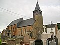
St.Pierre Church

A statue of Jesus in the town


See also[]
References[]
- ^ "Populations légales 2018". INSEE. 28 December 2020.
- ^ Population en historique depuis 1968, INSEE
| Wikimedia Commons has media related to Longfossé. |
show
Communes of the Pas-de-Calais department | |
|---|---|
|
This Pas-de-Calais geographical article is a stub. You can help Wikipedia by . |
- v
- t
Retrieved from ""
Categories:
- Communes of Pas-de-Calais
- Pas-de-Calais geography stubs
Hidden categories:
- Articles with short description
- Short description is different from Wikidata
- Coordinates on Wikidata
- Pages using infobox settlement with image map1 but not image map
- Commons category link from Wikidata
- Articles with BNF identifiers
- Articles with MusicBrainz area identifiers
- All stub articles
- Pages using the Kartographer extension