Villers-lès-Cagnicourt
Villers-lès-Cagnicourt | |
|---|---|
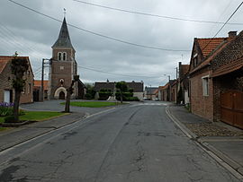 The centre of Villers-lès-Cagnicourt | |
show Location of Villers-lès-Cagnicourt | |
 Villers-lès-Cagnicourt | |
| Coordinates: 50°13′23″N 3°00′36″E / 50.2231°N 3.01°ECoordinates: 50°13′23″N 3°00′36″E / 50.2231°N 3.01°E | |
| Country | France |
| Region | Hauts-de-France |
| Department | Pas-de-Calais |
| Arrondissement | Arras |
| Canton | Brebières |
| Intercommunality | CC Osartis Marquion |
| Government | |
| • Mayor (2020–2026) | Yves Legros[1] |
| Area 1 | 4.4 km2 (1.7 sq mi) |
| Population (Jan. 2018)[2] | 260 |
| • Density | 59/km2 (150/sq mi) |
| Time zone | UTC+01:00 (CET) |
| • Summer (DST) | UTC+02:00 (CEST) |
| INSEE/Postal code | 62858 /62182 |
| Elevation | 47–79 m (154–259 ft) (avg. 54 m or 177 ft) |
| 1 French Land Register data, which excludes lakes, ponds, glaciers > 1 km2 (0.386 sq mi or 247 acres) and river estuaries. | |


Villers-lès-Cagnicourt is a commune in the Pas-de-Calais department in the Hauts-de-France region of France.
Geography[]
Villers-lès-Cagnicourt is situated some 15 miles (24.1 km) southeast of Arras, at the junction of the D939 and D13 roads.
History[]
The village church has plaques dedicated to several Canadian soldiers decorated for valour in the fighting nearby in 1918, including Sergeant Arthur George Knight, VC, of the 10th Battalion, CEF.
Population[]
| Year | 1962 | 1968 | 1975 | 1982 | 1990 | 1999 | 2006 |
|---|---|---|---|---|---|---|---|
| Population | 245 | 224 | 225 | 207 | 201 | 212 | 225 |
| From the year 1962 on: No double counting—residents of multiple communes (e.g. students and military personnel) are counted only once. | |||||||
Places of interest[]
- The church of St.Martin, rebuilt, along with much of the village, after World War I.
See also[]
References[]
- ^ "Répertoire national des élus: les maires". data.gouv.fr, Plateforme ouverte des données publiques françaises (in French). 2 December 2020.
- ^ "Populations légales 2018". INSEE. 28 December 2020.
| Wikimedia Commons has media related to Villers-lès-Cagnicourt. |
| show Authority control |
|---|
This Arras arrondissement, Pas-de-Calais geographical article is a stub. You can help Wikipedia by . |
Categories:
- Communes of Pas-de-Calais
- Arras arrondissement geography stubs