Sains-lès-Marquion
Sains-lès-Marquion | |
|---|---|
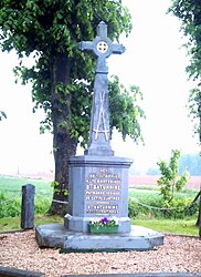 The commemorative stele to Sainte-Saturnine | |
 Coat of arms | |
show Location of Sains-lès-Marquion | |
 Sains-lès-Marquion | |
| Coordinates: 50°11′41″N 3°04′25″E / 50.1947°N 3.0736°ECoordinates: 50°11′41″N 3°04′25″E / 50.1947°N 3.0736°E | |
| Country | France |
| Region | Hauts-de-France |
| Department | Pas-de-Calais |
| Arrondissement | Arras |
| Canton | Bapaume |
| Intercommunality | CC Osartis Marquion |
| Government | |
| • Mayor (2020–2026) | Guy de Saint-Aubert[1] |
| Area 1 | 6.26 km2 (2.42 sq mi) |
| Population (Jan. 2018)[2] | 325 |
| • Density | 52/km2 (130/sq mi) |
| Time zone | UTC+01:00 (CET) |
| • Summer (DST) | UTC+02:00 (CEST) |
| INSEE/Postal code | 62739 /62860 |
| Elevation | 46–88 m (151–289 ft) (avg. 48 m or 157 ft) |
| 1 French Land Register data, which excludes lakes, ponds, glaciers > 1 km2 (0.386 sq mi or 247 acres) and river estuaries. | |


Sains-lès-Marquion is a commune in the Pas-de-Calais department in the Hauts-de-France region of France.
Geography[]
Sains-lès-Marquion lies about 19 miles (31 km) southeast of Arras, at the junction of the D15 and D16 roads.
Population[]
| Year | 1962 | 1968 | 1975 | 1982 | 1990 | 1999 | 2006 |
|---|---|---|---|---|---|---|---|
| Population | 350 | 351 | 324 | 315 | 276 | 300 | 333 |
| From the year 1962 on: No double counting—residents of multiple communes (e.g. students and military personnel) are counted only once. | |||||||
Places of interest[]
- The church of St. Saturnine, rebuilt along with much of the village after World War I.
- The war memorial.
- The Commonwealth War Graves Commission cemeteries.
See also[]
References[]
- ^ "Répertoire national des élus: les maires". data.gouv.fr, Plateforme ouverte des données publiques françaises (in French). 2 December 2020.
- ^ "Populations légales 2018". INSEE. 28 December 2020.
External links[]
| Wikimedia Commons has media related to Sains-lès-Marquion. |
| Authority control |
|
|---|
This Arras arrondissement, Pas-de-Calais geographical article is a stub. You can help Wikipedia by . |
Categories:
- Communes of Pas-de-Calais
- Arras arrondissement geography stubs