Estrée-Blanche
Estrée-Blanche
Strate | |
|---|---|
 The church of Estrée-Blanche | |
show Location of Estrée-Blanche | |
 Estrée-Blanche | |
| Coordinates: 50°35′38″N 2°19′19″E / 50.5939°N 2.3219°ECoordinates: 50°35′38″N 2°19′19″E / 50.5939°N 2.3219°E | |
| Country | France |
| Region | Hauts-de-France |
| Department | Pas-de-Calais |
| Arrondissement | Béthune |
| Canton | Aire-sur-la-Lys |
| Intercommunality | CA Béthune-Bruay, Artois-Lys Romane |
| Government | |
| • Mayor (2020–2026) | Bernard Delétré[1] |
| Area 1 | 5.32 km2 (2.05 sq mi) |
| Population (Jan. 2018)[2] | 934 |
| • Density | 180/km2 (450/sq mi) |
| Time zone | UTC+01:00 (CET) |
| • Summer (DST) | UTC+02:00 (CEST) |
| INSEE/Postal code | 62313 /62145 |
| Elevation | 37–99 m (121–325 ft) (avg. 43 m or 141 ft) |
| 1 French Land Register data, which excludes lakes, ponds, glaciers > 1 km2 (0.386 sq mi or 247 acres) and river estuaries. | |


Estrée-Blanche (French pronunciation: [ɛstʁe blɑ̃ʃ]; West Flemish: Strate) is a commune in the Pas-de-Calais department in the Hauts-de-France region of France.
History[]

Indian cavalry were stationed at Estrée-Blanche during the First World War.
Geography[]

Estrée-Blanche is a farming village some 12 miles (19.3 km) to the northwest of Béthune and 30 miles (48.3 km) west of Lille, at the junction of the D341, D186 and the D159 roads. The small rivers Surgeon and Laquette converge at the commune.
Estrée-Blanche is found at the extreme edge of the coal-mining area of Nord-Pas-de-Calais. Part of its surface area was owned by the mining company, which ceased in the 1960s. All that remains of that era are some typical miners' houses.
It is one of many villages in the north of France bearing the name Estrées. The etymology of the name is from strata (cognate of English "street"), the word for the stone-layered Roman roads in the area (some of which turned into modern highways). Hence Estreti, village on the road which developed into Estrées.
Population[]
| Year | 1962 | 1968 | 1975 | 1982 | 1990 | 1999 |
|---|---|---|---|---|---|---|
| Population | 1022 | 1093 | 1068 | 1005 | 988 | 928 |
| From the year 1962 on: No double counting—residents of multiple communes (e.g. students and military personnel) are counted only once. | ||||||
Places of interest[]
- The church of St.Vaast, dating from the sixteenth century.
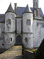
- The fifteenth-century , built by the Le May family in 1443
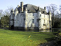
The château from the west
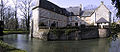
The rear courtyard
The towers and drawbridge

The château entrance


See also[]
References[]
- ^ "Répertoire national des élus: les maires". data.gouv.fr, Plateforme ouverte des données publiques françaises (in French). 2 December 2020.
- ^ "Populations légales 2018". INSEE. 28 December 2020.
| Wikimedia Commons has media related to Estrée-Blanche. |
This Pas-de-Calais geographical article is a stub. You can help Wikipedia by . |
- Communes of Pas-de-Calais
- Pas-de-Calais geography stubs