Wirwignes
From Wikipedia, the free encyclopedia
Commune in Hauts-de-France, France
Wirwignes
Willewine | |
|---|---|
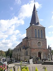 The church of Wirwignes | |
 Coat of arms | |
 Wirwignes  Wirwignes | |
Coordinates:  50°41′09″N 1°45′43″E / 50.6858°N 1.7619°E / 50.6858; 1.7619Coordinates: 50°41′09″N 1°45′43″E / 50.6858°N 1.7619°E / 50.6858; 1.7619 50°41′09″N 1°45′43″E / 50.6858°N 1.7619°E / 50.6858; 1.7619Coordinates: 50°41′09″N 1°45′43″E / 50.6858°N 1.7619°E / 50.6858; 1.7619 | |
| Country | France |
| Region | Hauts-de-France |
| Department | Pas-de-Calais |
| Arrondissement | Boulogne-sur-Mer |
| Canton | Desvres |
| Intercommunality | Desvres-Samer |
| Government | |
| • Mayor (2020–2026) | André Goudalle |
| Area 1 | 12.47 km2 (4.81 sq mi) |
| Population (Jan. 2018)[1] | 742 |
| • Density | 60/km2 (150/sq mi) |
| Time zone | UTC+01:00 (CET) |
| • Summer (DST) | UTC+02:00 (CEST) |
| INSEE/Postal code | 62896 /62240 |
| Elevation | 22–102 m (72–335 ft) (avg. 28 m or 92 ft) |
| 1 French Land Register data, which excludes lakes, ponds, glaciers > 1 km2 (0.386 sq mi or 247 acres) and river estuaries. | |

Wirwignes (West Flemish: Willewine) is a commune in the Pas-de-Calais department in the Hauts-de-France region of France.
Geography[]
Wirwignes is situated some 8 miles (13 km) southeast of Boulogne, at the junction of the D238 and the D341 roads, on the banks of the river Liane.
Population[]
| Year | Pop. | ±% |
|---|---|---|
| 2006 | 686 | — |
| 2007 | 704 | +2.6% |
| 2008 | 721 | +2.4% |
| 2009 | 739 | +2.5% |
| 2010 | 741 | +0.3% |
| 2011 | 738 | −0.4% |
| 2012 | 739 | +0.1% |
| 2013 | 739 | +0.0% |
| 2014 | 740 | +0.1% |
| 2015 | 738 | −0.3% |
| 2016 | 749 | +1.5% |
Places of interest[]
- The church of St.Quentin, dating from the fifteenth century.
- The château de Quenneval, dating from the seventeenth century.
- A seventeenth century fortified manorhouse.
See also[]
References[]
- ^ "Populations légales 2018". INSEE. 28 December 2020.
| Wikimedia Commons has media related to Wirwignes. |
show
Communes of the Pas-de-Calais department | |
|---|---|
|
This Pas-de-Calais geographical article is a stub. You can help Wikipedia by . |
- v
- t
Retrieved from ""
Categories:
- Communes of Pas-de-Calais
- Pas-de-Calais geography stubs
Hidden categories:
- Articles with short description
- Short description is different from Wikidata
- Coordinates on Wikidata
- Pages using infobox settlement with image map1 but not image map
- Articles containing West Flemish-language text
- Commons category link from Wikidata
- Articles with BNF identifiers
- All stub articles
- Pages using the Kartographer extension