Ablain-Saint-Nazaire
Ablain-Saint-Nazaire | |
|---|---|
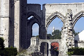 Ruins of the church destroyed during World War I | |
 Coat of arms | |
show Location of Ablain-Saint-Nazaire | |
 Ablain-Saint-Nazaire | |
| Coordinates: 50°23′34″N 2°42′48″E / 50.3928°N 2.7133°ECoordinates: 50°23′34″N 2°42′48″E / 50.3928°N 2.7133°E | |
| Country | France |
| Region | Hauts-de-France |
| Department | Pas-de-Calais |
| Arrondissement | Lens |
| Canton | Bully-les-Mines |
| Intercommunality | Lens-Liévin |
| Government | |
| • Mayor (2020-2026) | Éric Sevin |
| Area 1 | 9.85 km2 (3.80 sq mi) |
| Population (Jan. 2018)[1] | 1,824 |
| • Density | 190/km2 (480/sq mi) |
| Demonym(s) | Ablainois, Ablainoises |
| Time zone | UTC+01:00 (CET) |
| • Summer (DST) | UTC+02:00 (CEST) |
| INSEE/Postal code | 62001 /62153 |
| Elevation | 77–188 m (253–617 ft) (avg. 95 m or 312 ft) |
| 1 French Land Register data, which excludes lakes, ponds, glaciers > 1 km2 (0.386 sq mi or 247 acres) and river estuaries. | |


Ablain-Saint-Nazaire is a commune in the Pas-de-Calais department in northern France.
Geography[]
A farming village located 8 miles (12 km) north of Arras, on the D57 road. It was rebuilt after being destroyed during World War I. The Saint-Nazaire stream, which passes through the commune, is a small tributary of the river Deûle.
Population[]
|
| |||||||||||||||||||||||||||||||||||||||||||||||||||||||||||||||||||||||||||||||||||||||||||||||||||||||||||||||||||||||||||||||||||||||||||||||||||
| Source: EHESS (1793-2006)[2] and INSEE[3][4] | ||||||||||||||||||||||||||||||||||||||||||||||||||||||||||||||||||||||||||||||||||||||||||||||||||||||||||||||||||||||||||||||||||||||||||||||||||||
Politics[]
Presidential Elections Second Round:[5]
| Election | Winning Candidate | Party | % | |
|---|---|---|---|---|
| 2017 | Emmanuel Macron | EM | 58.26 | |
| 2012 | François Hollande | PS | 50.51 | |
| 2007 | Nicolas Sarkozy | UMP | 51.69 | |
| 2002 | Jacques Chirac | RPR | 77.47 | |
History[]
At the start of World War I, the Battle of Lorette lasted for 12 months, from October 1914 to October 1915, resulting in high casualties on both sides: 100,000 killed and as many wounded. A French national cemetery was built on 13 hectares nearby and comprises 20,000 graves, laid out irrespective of rank or military training. General Barbot has a private soldier buried next to him, on his right. In eight ossuaries, around the base of the lantern tower, are the remains of 22,970 unidentified soldiers. A portion of the cemetery has been reserved for Muslim soldiers.
In 2014, to mark the centenary of the start of World War I, French President François Hollande and German defence minister Ursula von der Leyen inaugurated a memorial for Armistice Day.[6]
Sights[]
- The church of St. Pierre, dating from the twentieth century.
- The ruins of the fifteenth century church, destroyed in World War I.
- The war museum.
See also[]
References[]
- ^ "Populations légales 2018". INSEE. 28 December 2020.
- ^ Des villages de Cassini aux communes d'aujourd'hui: Commune data sheet Ablain-Saint-Nazaire, EHESS. (in French)
- ^ Population en historique depuis 1968, INSEE
- ^ Populations légales 2018
- ^ "Résultats France - Présidentielle 2017 - 1er et 2nd tour".
- ^ Natalie Muller (11 November 2014), Hollande, von der Leyen, Europe observe Armistice DayDeutsche Welle.
External links[]
| Wikimedia Commons has media related to Ablain-Saint-Nazaire. |
- The Communauté d'Agglomération of Lens-Liévin (in French)
- Official website of Ablain-Saint-Nazaire (in French)
| show Authority control |
|---|
This Pas-de-Calais geographical article is a stub. You can help Wikipedia by . |
This World War I article is a stub. You can help Wikipedia by . |
- Communes of Pas-de-Calais
- Pas-de-Calais geography stubs
- World War I stubs