Autingues
From Wikipedia, the free encyclopedia
Commune in Hauts-de-France, France
Autingues | |
|---|---|
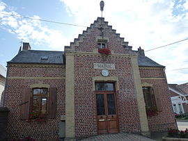 The town hall of Autingues | |
 Coat of arms | |
 Autingues  Autingues | |
Coordinates:  50°50′19″N 1°58′45″E / 50.8386°N 1.9792°E / 50.8386; 1.9792Coordinates: 50°50′19″N 1°58′45″E / 50.8386°N 1.9792°E / 50.8386; 1.9792 50°50′19″N 1°58′45″E / 50.8386°N 1.9792°E / 50.8386; 1.9792Coordinates: 50°50′19″N 1°58′45″E / 50.8386°N 1.9792°E / 50.8386; 1.9792 | |
| Country | France |
| Region | Hauts-de-France |
| Department | Pas-de-Calais |
| Arrondissement | Calais |
| Canton | Calais-2 |
| Intercommunality | Communauté de communes des Pays d'Opale |
| Government | |
| • Mayor (2020–2026) | Blaise de Saint-Just d'Autingues[1] |
| Area 1 | 2.97 km2 (1.15 sq mi) |
| Population (Jan. 2018)[2] | 290 |
| • Density | 98/km2 (250/sq mi) |
| Time zone | UTC+01:00 (CET) |
| • Summer (DST) | UTC+02:00 (CEST) |
| INSEE/Postal code | 62059 /62610 |
| Elevation | 4–45 m (13–148 ft) (avg. 21 m or 69 ft) |
| 1 French Land Register data, which excludes lakes, ponds, glaciers > 1 km2 (0.386 sq mi or 247 acres) and river estuaries. | |

Autingues is a commune in the Pas-de-Calais department in northern France.
Geography[]
A village located 10 miles (16 km) southeast of Calais, at the junction of the D225 with the D227 road.
Population[]
| Year | Pop. | ±% |
|---|---|---|
| 1962 | 146 | — |
| 1968 | 182 | +24.7% |
| 1975 | 223 | +22.5% |
| 1982 | 230 | +3.1% |
| 1990 | 224 | −2.6% |
| 1999 | 255 | +13.8% |
| 2005 | 296 | +16.1% |
| 2009 | 302 | +2.0% |
| 2010 | 298 | −1.3% |
| 2015 | 288 | −3.4% |
Sights[]
- The eighteenth-century church of St. Louis.
- The eighteenth-century château.
See also[]
References[]
- ^ "Répertoire national des élus: les maires". data.gouv.fr, Plateforme ouverte des données publiques françaises (in French). 2 December 2020.
- ^ "Populations légales 2018". INSEE. 28 December 2020.
| Wikimedia Commons has media related to Autingues. |
show
Communes of the Pas-de-Calais department | |
|---|---|
|
This Pas-de-Calais geographical article is a stub. You can help Wikipedia by . |
- v
- t
Retrieved from ""
Categories:
- Communes of Pas-de-Calais
- Pas-de-Calais geography stubs
Hidden categories:
- CS1 French-language sources (fr)
- Articles with short description
- Short description is different from Wikidata
- Coordinates on Wikidata
- Pages using infobox settlement with image map1 but not image map
- Commons category link is on Wikidata
- Articles with BNF identifiers
- All stub articles
- Pages using the Kartographer extension