Baincthun
From Wikipedia, the free encyclopedia
Commune in Hauts-de-France, France
Baincthun | |
|---|---|
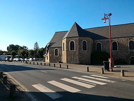 The church square of Baincthun | |
 Coat of arms | |
 Baincthun  Baincthun | |
Coordinates:  50°42′38″N 1°40′52″E / 50.7106°N 1.6811°E / 50.7106; 1.6811Coordinates: 50°42′38″N 1°40′52″E / 50.7106°N 1.6811°E / 50.7106; 1.6811 50°42′38″N 1°40′52″E / 50.7106°N 1.6811°E / 50.7106; 1.6811Coordinates: 50°42′38″N 1°40′52″E / 50.7106°N 1.6811°E / 50.7106; 1.6811 | |
| Country | France |
| Region | Hauts-de-France |
| Department | Pas-de-Calais |
| Arrondissement | Boulogne-sur-Mer |
| Canton | Boulogne-sur-Mer-2 |
| Intercommunality | CA Boulonnais |
| Government | |
| • Mayor (2020–2026) | Stéphane Bourgeois |
| Area 1 | 26.69 km2 (10.31 sq mi) |
| Population (Jan. 2018)[1] | 1,293 |
| • Density | 48/km2 (130/sq mi) |
| Time zone | UTC+01:00 (CET) |
| • Summer (DST) | UTC+02:00 (CEST) |
| INSEE/Postal code | 62075 /62360 |
| Elevation | 22–133 m (72–436 ft) (avg. 32 m or 105 ft) |
| 1 French Land Register data, which excludes lakes, ponds, glaciers > 1 km2 (0.386 sq mi or 247 acres) and river estuaries. | |

Baincthun (French: [bɛ̃ktœ̃]) is a commune in the Pas-de-Calais department in the Hauts-de-France region of France.
Geography[]
A farming and quarrying commune, some 4 miles (6.4 km) southeast of Boulogne, at the junction of the D341 and the D234 roads.
Population[]
| Year | Pop. | ±% |
|---|---|---|
| 1962 | 1,049 | — |
| 1968 | 1,082 | +3.1% |
| 1975 | 1,071 | −1.0% |
| 1982 | 1,087 | +1.5% |
| 1990 | 1,147 | +5.5% |
| 1999 | 1,207 | +5.2% |
| 2004 | 1,316 | +9.0% |
| 2009 | 1,350 | +2.6% |
| 2014 | 1,300 | −3.7% |
| 2015 | 1,293 | −0.5% |
Sights[]
- A feudal motte.
- The church of St. Martin.
- The Château d'Ordre, dating from 1672 at the hamlet of Maquinghen.
- The manor at Lannoy.
See also[]
References[]
- ^ "Populations légales 2018". INSEE. 28 December 2020.
| Wikimedia Commons has media related to Baincthun. |
show
Communes of the Pas-de-Calais department | |
|---|---|
|
This Pas-de-Calais geographical article is a stub. You can help Wikipedia by . |
- v
- t
Retrieved from ""
Categories:
- Communes of Pas-de-Calais
- Pas-de-Calais geography stubs
Hidden categories:
- Articles with short description
- Short description is different from Wikidata
- Coordinates on Wikidata
- Pages using infobox settlement with image map1 but not image map
- Commons category link is on Wikidata
- Articles with BNF identifiers
- All stub articles
- Pages using the Kartographer extension