Bainghen
From Wikipedia, the free encyclopedia
Commune in Hauts-de-France, France
Bainghen | |
|---|---|
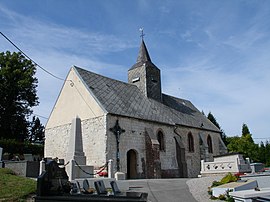 The church of Bainghen | |
 Coat of arms | |
 Bainghen  Bainghen | |
Coordinates:  50°45′08″N 1°54′28″E / 50.7522°N 1.9078°E / 50.7522; 1.9078Coordinates: 50°45′08″N 1°54′28″E / 50.7522°N 1.9078°E / 50.7522; 1.9078 50°45′08″N 1°54′28″E / 50.7522°N 1.9078°E / 50.7522; 1.9078Coordinates: 50°45′08″N 1°54′28″E / 50.7522°N 1.9078°E / 50.7522; 1.9078 | |
| Country | France |
| Region | Hauts-de-France |
| Department | Pas-de-Calais |
| Arrondissement | Calais |
| Canton | Calais-2 |
| Intercommunality | Communauté de communes des Pays d'Opale |
| Government | |
| • Mayor (2020–2026) | Thierry Terlutte[1] |
| Area 1 | 6.69 km2 (2.58 sq mi) |
| Population (Jan. 2018)[2] | 223 |
| • Density | 33/km2 (86/sq mi) |
| Time zone | UTC+01:00 (CET) |
| • Summer (DST) | UTC+02:00 (CEST) |
| INSEE/Postal code | 62076 /62850 |
| Elevation | 77–202 m (253–663 ft) (avg. 200 m or 660 ft) |
| 1 French Land Register data, which excludes lakes, ponds, glaciers > 1 km2 (0.386 sq mi or 247 acres) and river estuaries. | |

Bainghen is a commune in the Pas-de-Calais department in the Hauts-de-France region of France.
Geography[]
A small farming commune, some 14 miles (23 km) east of Boulogne, at the junction of the D206 and the D206e roads.
Population[]
| Year | Pop. | ±% |
|---|---|---|
| 1962 | 112 | — |
| 1968 | 135 | +20.5% |
| 1975 | 130 | −3.7% |
| 1982 | 122 | −6.2% |
| 1990 | 135 | +10.7% |
| 1999 | 126 | −6.7% |
| 2004 | 142 | +12.7% |
| 2009 | 181 | +27.5% |
| 2014 | 217 | +19.9% |
| 2015 | 227 | +4.6% |
Sights[]
- The ruins of a feudal chateau.
- The church of St. Martin, dating from the eighteenth century.
See also[]
References[]
- ^ "Répertoire national des élus: les maires". data.gouv.fr, Plateforme ouverte des données publiques françaises (in French). 2 December 2020.
- ^ "Populations légales 2018". INSEE. 28 December 2020.
| Wikimedia Commons has media related to Bainghen. |
show
Communes of the Pas-de-Calais department | |
|---|---|
|
This Pas-de-Calais geographical article is a stub. You can help Wikipedia by . |
- v
- t
Retrieved from ""
Categories:
- Communes of Pas-de-Calais
- Pas-de-Calais geography stubs
Hidden categories:
- CS1 French-language sources (fr)
- Articles with short description
- Short description is different from Wikidata
- Coordinates on Wikidata
- Pages using infobox settlement with image map1 but not image map
- Commons category link is on Wikidata
- Articles with BNF identifiers
- All stub articles
- Pages using the Kartographer extension