Bouvelinghem
From Wikipedia, the free encyclopedia
Commune in Hauts-de-France, France
Bouvelinghem
Bovelingem | |
|---|---|
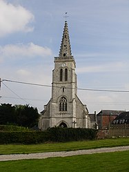 The church of Bouvelinghem | |
 Coat of arms | |
 Bouvelinghem  Bouvelinghem | |
Coordinates:  50°44′03″N 2°01′58″E / 50.7342°N 2.0328°E / 50.7342; 2.0328Coordinates: 50°44′03″N 2°01′58″E / 50.7342°N 2.0328°E / 50.7342; 2.0328 50°44′03″N 2°01′58″E / 50.7342°N 2.0328°E / 50.7342; 2.0328Coordinates: 50°44′03″N 2°01′58″E / 50.7342°N 2.0328°E / 50.7342; 2.0328 | |
| Country | France |
| Region | Hauts-de-France |
| Department | Pas-de-Calais |
| Arrondissement | Saint-Omer |
| Canton | Lumbres |
| Intercommunality | Pays de Lumbres |
| Government | |
| • Mayor (2020–2026) | Dominique Sénécat[1] |
| Area 1 | 6.28 km2 (2.42 sq mi) |
| Population (Jan. 2018)[2] | 229 |
| • Density | 36/km2 (94/sq mi) |
| Time zone | UTC+01:00 (CET) |
| • Summer (DST) | UTC+02:00 (CEST) |
| INSEE/Postal code | 62169 /62380 |
| Elevation | 98–196 m (322–643 ft) (avg. 175 m or 574 ft) |
| 1 French Land Register data, which excludes lakes, ponds, glaciers > 1 km2 (0.386 sq mi or 247 acres) and river estuaries. | |

Bouvelinghem (West Flemish: Bovelingem) is a commune in the Pas-de-Calais department in the Hauts-de-France region in northern France.
Geography[]
A village situated 10 miles (16 km) west of Saint-Omer, on the D208 road. It was completely destroyed by fire in 1876.
Population[]
| Year | Pop. | ±% |
|---|---|---|
| 1962 | 127 | — |
| 1968 | 155 | +22.0% |
| 1975 | 179 | +15.5% |
| 1982 | 158 | −11.7% |
| 1990 | 162 | +2.5% |
| 1999 | 142 | −12.3% |
| 2009 | 234 | +64.8% |
Sights[]
- The church of the Assumption, dating from the early 20th century.
- The ruins of a chateau.
See also[]
References[]
- ^ "Répertoire national des élus: les maires". data.gouv.fr, Plateforme ouverte des données publiques françaises (in French). 2 December 2020.
- ^ "Populations légales 2018". INSEE. 28 December 2020.
| Wikimedia Commons has media related to Bouvelinghem. |
show
Communes of the Pas-de-Calais department | |
|---|---|
|
This Pas-de-Calais geographical article is a stub. You can help Wikipedia by . |
- v
- t
Retrieved from ""
Categories:
- Communes of Pas-de-Calais
- Pas-de-Calais geography stubs
Hidden categories:
- CS1 French-language sources (fr)
- Articles with short description
- Short description is different from Wikidata
- Coordinates on Wikidata
- Pages using infobox settlement with image map1 but not image map
- Articles containing West Flemish-language text
- Commons category link is on Wikidata
- Articles with BNF identifiers
- All stub articles
- Pages using the Kartographer extension