Canettemont
Canettemont | |
|---|---|
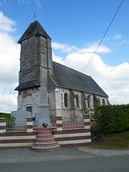 The church of Canettemont | |
 Coat of arms | |
show Location of Canettemont | |
 Canettemont | |
| Coordinates: 50°16′43″N 2°21′59″E / 50.2786°N 2.3664°ECoordinates: 50°16′43″N 2°21′59″E / 50.2786°N 2.3664°E | |
| Country | France |
| Region | Hauts-de-France |
| Department | Pas-de-Calais |
| Arrondissement | Arras |
| Canton | Avesnes-le-Comte |
| Intercommunality | CC Campagnes de l'Artois |
| Government | |
| • Mayor (2020–2026) | Christian Boucly[1] |
| Area 1 | 1.79 km2 (0.69 sq mi) |
| Population (Jan. 2018)[2] | 70 |
| • Density | 39/km2 (100/sq mi) |
| Time zone | UTC+01:00 (CET) |
| • Summer (DST) | UTC+02:00 (CEST) |
| INSEE/Postal code | 62208 /62270 |
| Elevation | 110–149 m (361–489 ft) (avg. 145 m or 476 ft) |
| 1 French Land Register data, which excludes lakes, ponds, glaciers > 1 km2 (0.386 sq mi or 247 acres) and river estuaries. | |


Canettemont is a commune in the Pas-de-Calais department in the Hauts-de-France region of France.
Geography[]
A small farming village located 20 miles (32 km) west of Arras at the junction of the D53 with the D84.
Population[]
| Year | 1962 | 1968 | 1975 | 1982 | 1990 | 1999 | 2006 | 2007 | 2012 | 2017 |
|---|---|---|---|---|---|---|---|---|---|---|
| Population | 52 | 65 | 60 | 57 | 67 | 61 | 60 | 60 | 68 | 68 |
| From the year 1962 on: No double counting—residents of multiple communes (e.g. students and military personnel) are counted only once. | ||||||||||
Places of interest[]
- The church of Notre-Dame dates from the sixteenth century.
See also[]
References[]
- ^ "Répertoire national des élus: les maires". data.gouv.fr, Plateforme ouverte des données publiques françaises (in French). 2 December 2020.
- ^ "Populations légales 2018". INSEE. 28 December 2020.
| Wikimedia Commons has media related to Canettemont. |
This Arras arrondissement, Pas-de-Calais geographical article is a stub. You can help Wikipedia by . |
Categories:
- Communes of Pas-de-Calais
- Arras arrondissement geography stubs