Chelers
Chelers | |
|---|---|
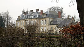 The chateau of Chelers | |
 Coat of arms | |
show Location of Chelers | |
 Chelers | |
| Coordinates: 50°22′35″N 2°29′10″E / 50.3764°N 2.4861°ECoordinates: 50°22′35″N 2°29′10″E / 50.3764°N 2.4861°E | |
| Country | France |
| Region | Hauts-de-France |
| Department | Pas-de-Calais |
| Arrondissement | Arras |
| Canton | Avesnes-le-Comte |
| Intercommunality | CC Campagnes de l'Artois |
| Government | |
| • Mayor (2020–2026) | Raymond Wacheux[1] |
| Area 1 | 8.04 km2 (3.10 sq mi) |
| Population (Jan. 2018)[2] | 251 |
| • Density | 31/km2 (81/sq mi) |
| Time zone | UTC+01:00 (CET) |
| • Summer (DST) | UTC+02:00 (CEST) |
| INSEE/Postal code | 62221 /62127 |
| Elevation | 126–158 m (413–518 ft) (avg. 148 m or 486 ft) |
| 1 French Land Register data, which excludes lakes, ponds, glaciers > 1 km2 (0.386 sq mi or 247 acres) and river estuaries. | |


Chelers is a commune in the Pas-de-Calais department in the Hauts-de-France region of France.
Geography[]
A farming village located 13 miles (22 km) west-northwest of Arras at the junction of the D77 with the D72 road.
Population[]
| Year | 1962 | 1968 | 1975 | 1982 | 1990 | 1999 |
|---|---|---|---|---|---|---|
| Population | 282 | 301 | 284 | 286 | 260 | 258 |
| From the year 1962 on: No double counting—residents of multiple communes (e.g. students and military personnel) are counted only once. | ||||||
Places of interest[]
- The church of St.Martin, dating from the eighteenth century.
- The Commonwealth War Graves Commission cemetery.
- An eighteenth-century chateau.
See also[]
References[]
- ^ "Répertoire national des élus: les maires". data.gouv.fr, Plateforme ouverte des données publiques françaises (in French). 2 December 2020.
- ^ "Populations légales 2018". INSEE. 28 December 2020.
External links[]
| Wikimedia Commons has media related to Chelers. |
This Arras arrondissement, Pas-de-Calais geographical article is a stub. You can help Wikipedia by . |
Categories:
- Communes of Pas-de-Calais
- Arras arrondissement geography stubs