Courset
This article needs additional citations for verification. (June 2011) |
Courset | |
|---|---|
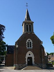 The church of Courset | |
 Coat of arms | |
show Location of Courset | |
 Courset | |
| Coordinates: 50°38′49″N 1°50′32″E / 50.6469°N 1.8422°ECoordinates: 50°38′49″N 1°50′32″E / 50.6469°N 1.8422°E | |
| Country | France |
| Region | Hauts-de-France |
| Department | Pas-de-Calais |
| Arrondissement | Boulogne-sur-Mer |
| Canton | Desvres |
| Intercommunality | CC Desvres-Samer |
| Government | |
| • Mayor (2020–2026) | Marc Denavaut[1] |
| Area 1 | 10.24 km2 (3.95 sq mi) |
| Population (Jan. 2018)[2] | 515 |
| • Density | 50/km2 (130/sq mi) |
| Time zone | UTC+01:00 (CET) |
| • Summer (DST) | UTC+02:00 (CEST) |
| INSEE/Postal code | 62251 /62240 |
| Elevation | 121–209 m (397–686 ft) (avg. 118 m or 387 ft) |
| 1 French Land Register data, which excludes lakes, ponds, glaciers > 1 km2 (0.386 sq mi or 247 acres) and river estuaries. | |


Courset is a commune in the Pas-de-Calais department in the Hauts-de-France region of France.
Geography[]
A farming and forestry village, some 12 miles (19 km) southeast of Boulogne, on the D127 road.
Population[]
| Year | 1962 | 1968 | 1975 | 1982 | 1990 | 1999 |
|---|---|---|---|---|---|---|
| Population | 321 | 328 | 363 | 334 | 365 | 396 |
| From the year 1962 on: No double counting—residents of multiple communes (e.g. students and military personnel) are counted only once. | ||||||
Places of interest[]
- The church of St. Maurice, dating from the sixteenth century.
- The nineteenth-century chateau de Courset.
- The seventeenth-century manorhouse of la Gaverie.
- Remains of an old castle.
See also[]
References[]
- ^ "Répertoire national des élus: les maires". data.gouv.fr, Plateforme ouverte des données publiques françaises (in French). 2 December 2020.
- ^ "Populations légales 2018". INSEE. 28 December 2020.
| Wikimedia Commons has media related to Courset. |
This Pas-de-Calais geographical article is a stub. You can help Wikipedia by . |
Categories:
- Communes of Pas-de-Calais
- Pas-de-Calais geography stubs