Croisette, Pas-de-Calais
Croisette | |
|---|---|
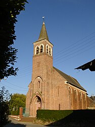 The church of Croisette | |
 Coat of arms | |
show Location of Croisette | |
 Croisette | |
| Coordinates: 50°21′15″N 2°15′42″E / 50.3542°N 2.2617°ECoordinates: 50°21′15″N 2°15′42″E / 50.3542°N 2.2617°E | |
| Country | France |
| Region | Hauts-de-France |
| Department | Pas-de-Calais |
| Arrondissement | Arras |
| Canton | Saint-Pol-sur-Ternoise |
| Intercommunality | CC Ternois |
| Government | |
| • Mayor (2020–2026) | Claude Bâchelet[1] |
| Area 1 | 7.64 km2 (2.95 sq mi) |
| Population (Jan. 2018)[2] | 276 |
| • Density | 36/km2 (94/sq mi) |
| Time zone | UTC+01:00 (CET) |
| • Summer (DST) | UTC+02:00 (CEST) |
| INSEE/Postal code | 62258 /62130 |
| Elevation | 114–146 m (374–479 ft) (avg. 141 m or 463 ft) |
| 1 French Land Register data, which excludes lakes, ponds, glaciers > 1 km2 (0.386 sq mi or 247 acres) and river estuaries. | |


Croisette is a commune in the Pas-de-Calais department in the Hauts-de-France region of France.
Geography[]
Croisette is located 24 miles (37 km) west of Arras at the junction of the D101 and D104 roads.
Population[]
The inhabitants are called Croisettois.
| Year | 1962 | 1968 | 1975 | 1982 | 1990 | 1999 |
|---|---|---|---|---|---|---|
| Population | 281 | 287 | 297 | 325 | 302 | 308 |
| From the year 1962 on: No double counting—residents of multiple communes (e.g. students and military personnel) are counted only once. | ||||||
Places of interest[]
- The church of St. Martin, dating from the seventeenth century
- The single Commonwealth War Graves Commission grave and monument
- Remains of a fortified house
- Two chapels
See also[]
References[]
- ^ "Répertoire national des élus: les maires". data.gouv.fr, Plateforme ouverte des données publiques françaises (in French). 2 December 2020.
- ^ "Populations légales 2018". INSEE. 28 December 2020.
External links[]
| Wikimedia Commons has media related to Croisette (Pas-de-Calais). |
This Arras arrondissement, Pas-de-Calais geographical article is a stub. You can help Wikipedia by . |
Categories:
- Communes of Pas-de-Calais
- Arras arrondissement geography stubs