Dainville
Dainville | |
|---|---|
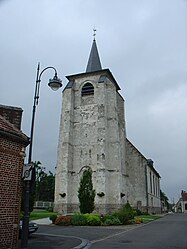 The church of Dainville | |
 Coat of arms | |
show Location of Dainville | |
 Dainville | |
| Coordinates: 50°16′58″N 2°43′41″E / 50.2828°N 2.7281°ECoordinates: 50°16′58″N 2°43′41″E / 50.2828°N 2.7281°E | |
| Country | France |
| Region | Hauts-de-France |
| Department | Pas-de-Calais |
| Arrondissement | Arras |
| Canton | Arras-1 |
| Intercommunality | Arras |
| Government | |
| • Mayor (2020–2026) | Françoise Rossignol[1] |
| Area 1 | 11.22 km2 (4.33 sq mi) |
| Population (Jan. 2018)[2] | 5,665 |
| • Density | 500/km2 (1,300/sq mi) |
| Time zone | UTC+01:00 (CET) |
| • Summer (DST) | UTC+02:00 (CEST) |
| INSEE/Postal code | 62263 /62000 |
| Elevation | 64–107 m (210–351 ft) (avg. 80 m or 260 ft) |
| 1 French Land Register data, which excludes lakes, ponds, glaciers > 1 km2 (0.386 sq mi or 247 acres) and river estuaries. | |


Dainville is a commune in the Pas-de-Calais department in the Hauts-de-France region of France.
Geography[]
A farming and light industrial suburb 2 miles (3.2 km) west of Arras at the junction of the N25 with the D60 and D59 roads.
Population[]
| Year | Pop. | ±% |
|---|---|---|
| 2006 | 5,306 | — |
| 2007 | 5,432 | +2.4% |
| 2008 | 5,444 | +0.2% |
| 2009 | 5,504 | +1.1% |
| 2010 | 5,569 | +1.2% |
| 2011 | 5,635 | +1.2% |
| 2012 | 5,825 | +3.4% |
| 2013 | 5,867 | +0.7% |
| 2014 | 5,768 | −1.7% |
| 2015 | 5,671 | −1.7% |
| 2016 | 5,573 | −1.7% |
Places of interest[]
- The church of St.Martin, dating from the thirteenth century
Twin towns[]
Dainville is twinned with the following town:
 Whitstable, Kent, England
See also[]
References[]
- ^ "Répertoire national des élus: les maires". data.gouv.fr, Plateforme ouverte des données publiques françaises (in French). 2 December 2020.
- ^ "Populations légales 2018". INSEE. 28 December 2020.
External links[]
| Wikimedia Commons has media related to Dainville. |
- The CWGC cemetery at Dainville
- The communal cemetery
- Official website of Dainville (in French)
- Official website of the communauté urbaine d'Arras (in French)
| show Authority control |
|---|
This Arras arrondissement, Pas-de-Calais geographical article is a stub. You can help Wikipedia by . |
Categories:
- Communes of Pas-de-Calais
- Arras arrondissement geography stubs