Drocourt, Pas-de-Calais
Drocourt | |
|---|---|
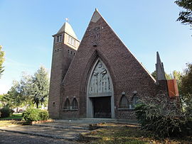 The church of Drocourt | |
 Coat of arms | |
show Location of Drocourt | |
 Drocourt | |
| Coordinates: 50°23′31″N 2°55′39″E / 50.3919°N 2.9275°ECoordinates: 50°23′31″N 2°55′39″E / 50.3919°N 2.9275°E | |
| Country | France |
| Region | Hauts-de-France |
| Department | Pas-de-Calais |
| Arrondissement | Lens |
| Canton | Hénin-Beaumont-2 |
| Intercommunality | CA Hénin-Carvin |
| Government | |
| • Mayor (2008–2014) | Bernard Czerwinski |
| Area 1 | 3.4 km2 (1.3 sq mi) |
| Population (Jan. 2018)[1] | 2,924 |
| • Density | 860/km2 (2,200/sq mi) |
| Time zone | UTC+01:00 (CET) |
| • Summer (DST) | UTC+02:00 (CEST) |
| INSEE/Postal code | 62277 /62320 |
| Elevation | 39–68 m (128–223 ft) (avg. 41 m or 135 ft) |
| 1 French Land Register data, which excludes lakes, ponds, glaciers > 1 km2 (0.386 sq mi or 247 acres) and river estuaries. | |


Drocourt is a commune in the Pas-de-Calais department in the Hauts-de-France region of France.
Geography[]
An ex-coalmining commune, now a light industrial and farming town, situated some 6 miles (9.7 km) southeast of Lens, at the junction of the D919, D40 and D47 roads.
Population[]
| Year | 1962 | 1968 | 1975 | 1982 | 1990 | 1999 | 2004 |
|---|---|---|---|---|---|---|---|
| Population | 2247 | 2361 | 3035 | 3458 | 3341 | 3104 | 3115 |
| From the year 1962 on: No double counting—residents of multiple communes (e.g. students and military personnel) are counted only once. | |||||||
Places of interest[]
- The churches of St.Leger and of St. Barbe, both dating from the twentieth century.
International relations[]
Drocourt is twinned with Tokarnia, Poland.
See also[]
References[]
- Notes
- ^ "Populations légales 2018". INSEE. 28 December 2020.
External links[]
| Wikimedia Commons has media related to Drocourt (Pas-de-Calais). |
- A regional website (in French)
| show Authority control |
|---|
This Pas-de-Calais geographical article is a stub. You can help Wikipedia by . |
Categories:
- Communes of Pas-de-Calais
- Pas-de-Calais geography stubs