Eps, Pas-de-Calais
From Wikipedia, the free encyclopedia
Commune in Hauts-de-France, France
Eps | |
|---|---|
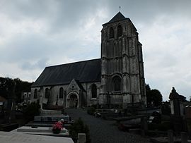 The church of Eps | |
 Coat of arms | |
 Eps  Eps | |
Coordinates:  50°27′20″N 2°17′48″E / 50.4556°N 2.2967°E / 50.4556; 2.2967Coordinates: 50°27′20″N 2°17′48″E / 50.4556°N 2.2967°E / 50.4556; 2.2967 50°27′20″N 2°17′48″E / 50.4556°N 2.2967°E / 50.4556; 2.2967Coordinates: 50°27′20″N 2°17′48″E / 50.4556°N 2.2967°E / 50.4556; 2.2967 | |
| Country | France |
| Region | Hauts-de-France |
| Department | Pas-de-Calais |
| Arrondissement | Arras |
| Canton | Saint-Pol-sur-Ternoise |
| Intercommunality | CC Ternois |
| Government | |
| • Mayor (2008–2014) | Arthur Hermant |
| Area 1 | 6.87 km2 (2.65 sq mi) |
| Population (Jan. 2018)[1] | 249 |
| • Density | 36/km2 (94/sq mi) |
| Time zone | UTC+01:00 (CET) |
| • Summer (DST) | UTC+02:00 (CEST) |
| INSEE/Postal code | 62299 /62134 |
| Elevation | 59–155 m (194–509 ft) (avg. 76 m or 249 ft) |
| 1 French Land Register data, which excludes lakes, ponds, glaciers > 1 km2 (0.386 sq mi or 247 acres) and river estuaries. | |

Eps is a commune in the Pas-de-Calais department in the Hauts-de-France region of France.
Geography[]
A farming village situated 27 miles (43.5 km) northwest of Arras at the junction of the D70 and D71 roads.
Places of interest[]
- The church of St. Martin, dating from the sixteenth century.
See also[]
References[]
- ^ "Populations légales 2018". INSEE. 28 December 2020.
External links[]
| Wikimedia Commons has media related to Eps. |
- Eps on the Quid website (in French)
show
Communes of the Pas-de-Calais department | |
|---|---|
|
This Arras arrondissement, Pas-de-Calais geographical article is a stub. You can help Wikipedia by . |
- v
- t
Retrieved from ""
Categories:
- Communes of Pas-de-Calais
- Arras arrondissement geography stubs
Hidden categories:
- Articles with short description
- Short description is different from Wikidata
- Infobox mapframe without OSM relation ID on Wikidata
- Coordinates on Wikidata
- Pages using infobox settlement with image map1 but not image map
- Commons category link is on Wikidata
- Articles with French-language sources (fr)
- Articles with VIAF identifiers
- Articles with BNF identifiers
- Articles with WORLDCATID identifiers
- All stub articles
- Pages using the Kartographer extension