Habarcq
Habarcq | |
|---|---|
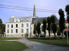 Church and chateau | |
 Coat of arms | |
show Location of Habarcq | |
 Habarcq | |
| Coordinates: 50°18′24″N 2°36′41″E / 50.3067°N 2.6114°ECoordinates: 50°18′24″N 2°36′41″E / 50.3067°N 2.6114°E | |
| Country | France |
| Region | Hauts-de-France |
| Department | Pas-de-Calais |
| Arrondissement | Arras |
| Canton | Avesnes-le-Comte |
| Intercommunality | Campagnes de l'Artois |
| Government | |
| • Mayor (2020–2026) | Nicolas Capron[1] |
| Area 1 | 7.03 km2 (2.71 sq mi) |
| Population (Jan. 2018)[2] | 667 |
| • Density | 95/km2 (250/sq mi) |
| Time zone | UTC+01:00 (CET) |
| • Summer (DST) | UTC+02:00 (CEST) |
| INSEE/Postal code | 62399 /62123 |
| Elevation | 77–136 m (253–446 ft) (avg. 94 m or 308 ft) |
| 1 French Land Register data, which excludes lakes, ponds, glaciers > 1 km2 (0.386 sq mi or 247 acres) and river estuaries. | |


Habarcq is a commune in the Pas-de-Calais department in the Hauts-de-France region of France.
Geography[]
A small farming village situated 8 miles (13 km) west of Arras, at the junction of the D339 and the D7 roads.
Population[]
| Year | Pop. | ±% |
|---|---|---|
| 2004 | 654 | — |
| 2006 | 667 | +2.0% |
| 2007 | 668 | +0.1% |
| 2008 | 670 | +0.3% |
| 2009 | 671 | +0.1% |
| 2010 | 677 | +0.9% |
| 2011 | 672 | −0.7% |
| 2012 | 675 | +0.4% |
| 2013 | 677 | +0.3% |
| 2014 | 679 | +0.3% |
| 2015 | 678 | −0.1% |
| 2016 | 684 | +0.9% |
Places of interest[]
- The church of St.Martin, dating from the sixteenth century.
- The ruins of an old castle.
- The chateau, dating from the eighteenth century.
- The Commonwealth War Graves Commission cemetery.
See also[]
References[]
- ^ "Répertoire national des élus: les maires". data.gouv.fr, Plateforme ouverte des données publiques françaises (in French). 2 December 2020.
- ^ "Populations légales 2018". INSEE. 28 December 2020.
External links[]
| Wikimedia Commons has media related to Habarcq. |

The church and chateau

Detail on the church spire


This Arras arrondissement, Pas-de-Calais geographical article is a stub. You can help Wikipedia by . |
Categories:
- Communes of Pas-de-Calais
- Arras arrondissement geography stubs