Houchin
Houchin | |
|---|---|
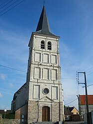 The church of Houchin | |
 Coat of arms | |
show Location of Houchin | |
 Houchin | |
| Coordinates: 50°29′00″N 2°37′23″E / 50.4833°N 2.6231°ECoordinates: 50°29′00″N 2°37′23″E / 50.4833°N 2.6231°E | |
| Country | France |
| Region | Hauts-de-France |
| Department | Pas-de-Calais |
| Arrondissement | Béthune |
| Canton | Nœux-les-Mines |
| Intercommunality | CA Béthune-Bruay, Artois-Lys Romane |
| Government | |
| • Mayor (2020–2026) | Maurice Leconte |
| Area 1 | 4.5 km2 (1.7 sq mi) |
| Population (Jan. 2018)[1] | 716 |
| • Density | 160/km2 (410/sq mi) |
| Time zone | UTC+01:00 (CET) |
| • Summer (DST) | UTC+02:00 (CEST) |
| INSEE/Postal code | 62456 /62620 |
| Elevation | 37–76 m (121–249 ft) (avg. 75 m or 246 ft) |
| 1 French Land Register data, which excludes lakes, ponds, glaciers > 1 km2 (0.386 sq mi or 247 acres) and river estuaries. | |


Houchin (French pronunciation: [uʃɛ̃]) is a commune in the Pas-de-Calais department in the Hauts-de-France region of France.
Geography[]
A farming village, situated some 3 miles (4.8 km) south of Béthune near the junction of the D72 and the D171 roads.
Population[]
| Year | 1962 | 1968 | 1975 | 1982 | 1990 | 1999 | 2006 |
|---|---|---|---|---|---|---|---|
| Population | 647 | 690 | 644 | 625 | 664 | 683 | 711 |
| From the year 1962 on: No double counting—residents of multiple communes (e.g. students and military personnel) are counted only once. | |||||||
Places of interest[]
- The church of St.Omer, dating from the seventeenth century.
- The Commonwealth War Graves Commission cemeteries.
See also[]
References[]
- ^ "Populations légales 2018". INSEE. 28 December 2020.
External links[]
| Wikimedia Commons has media related to Houchin. |
This Pas-de-Calais geographical article is a stub. You can help Wikipedia by . |
Categories:
- Communes of Pas-de-Calais
- Pas-de-Calais geography stubs