Hucqueliers
Hucqueliers
Hukkelaar | |
|---|---|
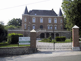 Château | |
 Coat of arms | |
Location of Hucqueliers  | |
 Hucqueliers | |
| Coordinates: 50°34′10″N 1°54′26″E / 50.5694°N 1.9072°ECoordinates: 50°34′10″N 1°54′26″E / 50.5694°N 1.9072°E | |
| Country | France |
| Region | Hauts-de-France |
| Department | Pas-de-Calais |
| Arrondissement | Montreuil |
| Canton | Lumbres |
| Intercommunality | CC Haut Pays du Montreuillois |
| Government | |
| • Mayor (2020–2026) | Stephane Leleu[1] |
| Area 1 | 7.62 km2 (2.94 sq mi) |
| Population (Jan. 2018)[2] | 451 |
| • Density | 59/km2 (150/sq mi) |
| Time zone | UTC+01:00 (CET) |
| • Summer (DST) | UTC+02:00 (CEST) |
| INSEE/Postal code | 62463 /62650 |
| Elevation | 92–172 m (302–564 ft) (avg. 94 m or 308 ft) |
| 1 French Land Register data, which excludes lakes, ponds, glaciers > 1 km2 (0.386 sq mi or 247 acres) and river estuaries. | |

Hucqueliers (West Flemish: Hukkelaar) is a commune in the department of Pas-de-Calais, in the northern French region of Hauts-de-France.
Geography[]
Situated some 10 miles (16 km) northeast of Montreuil-sur-Mer at the D148 and D128 crossroads.
Population[]
| Year | 1962 | 1968 | 1975 | 1982 | 1990 | 1999 | 2006 |
|---|---|---|---|---|---|---|---|
| Population | 521 | 555 | 558 | 528 | 539 | 505 | 591 |
| From the year 1962 on: No double counting—residents of multiple communes (e.g. students and military personnel) are counted only once. | |||||||
History[]
An important castle was built here in 1231 by the Count of Boulogne. Hucqueliers was the centre of resistance during the in 1662.
Places of interest[]
- The chateau, now an educational establishment.
- The church of St. André, dating from the fifteenth century.
- The eighteenth century Manoir de la Longeville.
See also[]
References[]
- ^ "Répertoire national des élus: les maires". data.gouv.fr, Plateforme ouverte des données publiques françaises (in French). 2 December 2020. Retrieved 7 December 2020.
- ^ "Populations légales 2018". INSEE. 28 December 2020.
External links[]
| Wikimedia Commons has media related to Hucqueliers. |
- Official Hucqueliers Site (in French)
This Pas-de-Calais geographical article is a stub. You can help Wikipedia by . |
Categories:
- Communes of Pas-de-Calais
- Pas-de-Calais geography stubs