Humbert, Pas-de-Calais
Humbert
Humberg | |
|---|---|
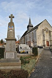 The monument to the dead and church of Humbert | |
 Coat of arms | |
show Location of Humbert | |
 Humbert | |
| Coordinates: 50°30′19″N 1°54′28″E / 50.5053°N 1.9078°ECoordinates: 50°30′19″N 1°54′28″E / 50.5053°N 1.9078°E | |
| Country | France |
| Region | Hauts-de-France |
| Department | Pas-de-Calais |
| Arrondissement | Montreuil |
| Canton | Lumbres |
| Intercommunality | CC Haut Pays du Montreuillois |
| Government | |
| • Mayor (2020–2026) | Jean-Claude Avisse[1] |
| Area 1 | 7.85 km2 (3.03 sq mi) |
| Population (Jan. 2018)[2] | 232 |
| • Density | 30/km2 (77/sq mi) |
| Time zone | UTC+01:00 (CET) |
| • Summer (DST) | UTC+02:00 (CEST) |
| INSEE/Postal code | 62466 /62650 |
| Elevation | 47–147 m (154–482 ft) (avg. 57 m or 187 ft) |
| 1 French Land Register data, which excludes lakes, ponds, glaciers > 1 km2 (0.386 sq mi or 247 acres) and river estuaries. | |


Humbert (West Flemish: Humberg) is a commune in the Pas-de-Calais department in the Hauts-de-France region of France.
Geography[]
Situated some 8 miles (12 km) northeast of Montreuil-sur-Mer on the D129 road.
Population[]
| Year | 1962 | 1968 | 1975 | 1982 | 1990 | 1999 | 2006 |
|---|---|---|---|---|---|---|---|
| Population | 228 | 238 | 225 | 196 | 248 | 254 | 252 |
| From the year 1962 on: No double counting—residents of multiple communes (e.g. students and military personnel) are counted only once. | |||||||
Places of interest[]
- The church of St.Peter, dating from the sixteenth century.
See also[]
References[]
- ^ "Répertoire national des élus: les maires". data.gouv.fr, Plateforme ouverte des données publiques françaises (in French). 2 December 2020. Retrieved 7 December 2020.
- ^ "Populations légales 2018". INSEE. 28 December 2020.
| Wikimedia Commons has media related to Humbert (Pas-de-Calais). |
This Pas-de-Calais geographical article is a stub. You can help Wikipedia by . |
Categories:
- Communes of Pas-de-Calais
- Pas-de-Calais geography stubs