Lapugnoy
Lapugnoy | |
|---|---|
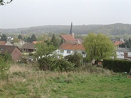 A general view of Lapugnoy | |
 Coat of arms | |
show Location of Lapugnoy | |
 Lapugnoy | |
| Coordinates: 50°31′02″N 2°32′28″E / 50.5172°N 2.5411°ECoordinates: 50°31′02″N 2°32′28″E / 50.5172°N 2.5411°E | |
| Country | France |
| Region | Hauts-de-France |
| Department | Pas-de-Calais |
| Arrondissement | Béthune |
| Canton | Béthune |
| Intercommunality | CA Béthune-Bruay, Artois-Lys Romane |
| Government | |
| • Mayor (2020–2026) | Alain Delannoy[1] |
| Area 1 | 8.61 km2 (3.32 sq mi) |
| Population (Jan. 2018)[2] | 3,467 |
| • Density | 400/km2 (1,000/sq mi) |
| Time zone | UTC+01:00 (CET) |
| • Summer (DST) | UTC+02:00 (CEST) |
| INSEE/Postal code | 62489 /62122 |
| Elevation | 24–93 m (79–305 ft) (avg. 37 m or 121 ft) |
| 1 French Land Register data, which excludes lakes, ponds, glaciers > 1 km2 (0.386 sq mi or 247 acres) and river estuaries. | |


Lapugnoy is a commune in the Pas-de-Calais department in the Hauts-de-France region of France.
Geography[]
A small farming and forestry town, situated some 5 miles (8.0 km) west of Béthune and 33 miles (53.1 km) southwest of Lille, on the D70 road, by the banks of the Clarence and traversed by the A26 autoroute..
Population[]
| Year | 1962 | 1968 | 1975 | 1982 | 1990 | 1999 | 2006 |
|---|---|---|---|---|---|---|---|
| Population | 2519 | 2645 | 3259 | 3375 | 3426 | 3310 | 3323 |
| From the year 1962 on: No double counting—residents of multiple communes (e.g. students and military personnel) are counted only once. | |||||||
Places of interest[]
- The Commonwealth War Graves Commission cemetery.
- The church of St. Vaast, dating from the nineteenth century.
See also[]
References[]
- ^ "Répertoire national des élus: les maires". data.gouv.fr, Plateforme ouverte des données publiques françaises (in French). 2 December 2020.
- ^ "Populations légales 2018". INSEE. 28 December 2020.
External links[]
| Wikimedia Commons has media related to Lapugnoy. |
This Pas-de-Calais geographical article is a stub. You can help Wikipedia by . |
Categories:
- Communes of Pas-de-Calais
- Pas-de-Calais geography stubs