Le Transloy
From Wikipedia, the free encyclopedia
Commune in Hauts-de-France, France
Le Transloy | |
|---|---|
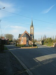 The church of Le Transloy | |
 Le Transloy  Le Transloy | |
Coordinates:  50°03′36″N 2°53′39″E / 50.06°N 2.8942°E / 50.06; 2.8942Coordinates: 50°03′36″N 2°53′39″E / 50.06°N 2.8942°E / 50.06; 2.8942 50°03′36″N 2°53′39″E / 50.06°N 2.8942°E / 50.06; 2.8942Coordinates: 50°03′36″N 2°53′39″E / 50.06°N 2.8942°E / 50.06; 2.8942 | |
| Country | France |
| Region | Hauts-de-France |
| Department | Pas-de-Calais |
| Arrondissement | Arras |
| Canton | Bapaume |
| Intercommunality | CC Sud-Artois |
| Government | |
| • Mayor (2008–2014) | Jean-Luc Capon |
| Area 1 | 10.41 km2 (4.02 sq mi) |
| Population (Jan. 2018)[1] | 421 |
| • Density | 40/km2 (100/sq mi) |
| Time zone | UTC+01:00 (CET) |
| • Summer (DST) | UTC+02:00 (CEST) |
| INSEE/Postal code | 62829 /62450 |
| Elevation | 108–151 m (354–495 ft) (avg. 110 m or 360 ft) |
| 1 French Land Register data, which excludes lakes, ponds, glaciers > 1 km2 (0.386 sq mi or 247 acres) and river estuaries. | |

Le Transloy is a commune in the Pas-de-Calais department in the Hauts-de-France region of France.
Geography[]
Le Transloy is situated 18 miles (29 km) south of Arras, at the junction of the N17 and the D19 roads.
Population[]
| Year | 1962 | 1968 | 1975 | 1982 | 1990 | 1999 | 2006 |
|---|---|---|---|---|---|---|---|
| Population | 421 | 447 | 405 | 399 | 390 | 371 | 424 |
| From the year 1962 on: No double counting—residents of multiple communes (e.g. students and military personnel) are counted only once. | |||||||
Places of interest[]
- The church of St.Nicholas, rebuilt along with the rest of the village, following World War I.
- A memorial to 800 French soldiers killed during fighting around Bapaume, in 1914.
See also[]
References[]
- ^ "Populations légales 2018". INSEE. 28 December 2020.
| Wikimedia Commons has media related to Le Transloy. |
show
Communes of the Pas-de-Calais department | |
|---|---|
|
This Arras arrondissement, Pas-de-Calais geographical article is a stub. You can help Wikipedia by . |
- v
- t
Retrieved from ""
Categories:
- Communes of Pas-de-Calais
- Arras arrondissement geography stubs
Hidden categories:
- Articles with short description
- Short description is different from Wikidata
- Infobox mapframe without OSM relation ID on Wikidata
- Coordinates on Wikidata
- Pages using infobox settlement with image map1 but not image map
- Commons category link from Wikidata
- Articles with VIAF identifiers
- Articles with BNF identifiers
- Articles with WORLDCATID identifiers
- All stub articles
- Pages using the Kartographer extension