Longuenesse
From Wikipedia, the free encyclopedia
Commune in Hauts-de-France, France
Longuenesse
Langenesse | |
|---|---|
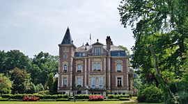 The town hall of Longuenesse | |
 Coat of arms | |
 Longuenesse  Longuenesse | |
Coordinates:  50°44′11″N 2°14′18″E / 50.7364°N 2.2383°E / 50.7364; 2.2383Coordinates: 50°44′11″N 2°14′18″E / 50.7364°N 2.2383°E / 50.7364; 2.2383 50°44′11″N 2°14′18″E / 50.7364°N 2.2383°E / 50.7364; 2.2383Coordinates: 50°44′11″N 2°14′18″E / 50.7364°N 2.2383°E / 50.7364; 2.2383 | |
| Country | France |
| Region | Hauts-de-France |
| Department | Pas-de-Calais |
| Arrondissement | Saint-Omer |
| Canton | Longuenesse |
| Intercommunality | Pays de Saint-Omer |
| Government | |
| • Mayor (2020–2026) | Christian Coupez |
| Area 1 | 8.4 km2 (3.2 sq mi) |
| Population (Jan. 2018)[1] | 10,736 |
| • Density | 1,300/km2 (3,300/sq mi) |
| Time zone | UTC+01:00 (CET) |
| • Summer (DST) | UTC+02:00 (CEST) |
| INSEE/Postal code | 62525 /62219 |
| Elevation | 3–79 m (9.8–259.2 ft) (avg. 75 m or 246 ft) |
| 1 French Land Register data, which excludes lakes, ponds, glaciers > 1 km2 (0.386 sq mi or 247 acres) and river estuaries. | |

Longuenesse (West Flemish: Langenesse) is a commune in the Pas-de-Calais department in the Hauts-de-France region of France.
Geography[]
Longuenesse is a large suburb of Saint-Omer, one mile southwest of the centre, on the D208 road.
Population[]
| Year | Pop. | ±% p.a. |
|---|---|---|
| 1968 | 4,794 | — |
| 1975 | 9,397 | +10.09% |
| 1982 | 11,970 | +3.52% |
| 1990 | 12,604 | +0.65% |
| 1999 | 12,518 | −0.08% |
| 2007 | 11,120 | −1.47% |
| 2012 | 11,108 | −0.02% |
| 2017 | 11,023 | −0.15% |
| Source: INSEE[2] | ||
Places of interest[]
- The church of St.Quentin, dating from the nineteenth century.
- An old abbey hostel.
- The fountain of Saint-Quentin.
- Vestiges of a monastery founded in 1298.
Twin towns[]
 , in Belgium
See also[]
References[]
- ^ "Populations légales 2018". INSEE. 28 December 2020.
- ^ Population en historique depuis 1968, INSEE
| Wikimedia Commons has media related to Longuenesse. |
show
Communes of the Pas-de-Calais department | |
|---|---|
|
This Pas-de-Calais geographical article is a stub. You can help Wikipedia by . |
- v
- t
Retrieved from ""
Categories:
- Communes of Pas-de-Calais
- Saint-Omer
- Pas-de-Calais geography stubs
Hidden categories:
- Articles with short description
- Short description is different from Wikidata
- Infobox mapframe without OSM relation ID on Wikidata
- Coordinates on Wikidata
- Pages using infobox settlement with image map1 but not image map
- Articles containing West Flemish-language text
- Commons category link from Wikidata
- Articles with BNF identifiers
- Articles with MusicBrainz area identifiers
- All stub articles
- Pages using the Kartographer extension