Marconnelle
From Wikipedia, the free encyclopedia
Commune in Hauts-de-France, France
Marconnelle | |
|---|---|
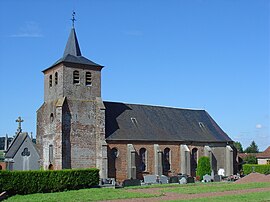 The church of Marconnelle | |
 Coat of arms | |
 Marconnelle  Marconnelle | |
Coordinates:  50°22′30″N 2°02′15″E / 50.375°N 2.0375°E / 50.375; 2.0375Coordinates: 50°22′30″N 2°02′15″E / 50.375°N 2.0375°E / 50.375; 2.0375 50°22′30″N 2°02′15″E / 50.375°N 2.0375°E / 50.375; 2.0375Coordinates: 50°22′30″N 2°02′15″E / 50.375°N 2.0375°E / 50.375; 2.0375 | |
| Country | France |
| Region | Hauts-de-France |
| Department | Pas-de-Calais |
| Arrondissement | Montreuil |
| Canton | Auxi-le-Château |
| Intercommunality | CC Sept Vallées |
| Government | |
| • Mayor (2020–2026) | Claude Bacquet |
| Area 1 | 5.55 km2 (2.14 sq mi) |
| Population (Jan. 2018)[1] | 1,116 |
| • Density | 200/km2 (520/sq mi) |
| Time zone | UTC+01:00 (CET) |
| • Summer (DST) | UTC+02:00 (CEST) |
| INSEE/Postal code | 62550 /62140 |
| Elevation | 22–133 m (72–436 ft) (avg. 81 m or 266 ft) |
| 1 French Land Register data, which excludes lakes, ponds, glaciers > 1 km2 (0.386 sq mi or 247 acres) and river estuaries. | |

Marconnelle is a commune in the Pas-de-Calais department in the Hauts-de-France region of France.
Geography[]
Marconelle is a large suburb of Hesdin, situated 13 miles (21 km) southeast of Montreuil-sur-Mer, on the D349 road.
Population[]
| Year | Pop. | ±% p.a. |
|---|---|---|
| 1968 | 986 | — |
| 1975 | 1,239 | +3.32% |
| 1982 | 1,489 | +2.66% |
| 1990 | 1,334 | −1.36% |
| 1999 | 1,312 | −0.18% |
| 2007 | 1,249 | −0.61% |
| 2012 | 1,181 | −1.11% |
| 2017 | 1,134 | −0.81% |
| Source: INSEE[2] | ||
Places of interest[]
- The church of Saint-Croix, dating from the eighteenth century.
See also[]
References[]
- ^ "Populations légales 2018". INSEE. 28 December 2020.
- ^ Population en historique depuis 1968, INSEE
| Wikimedia Commons has media related to Marconnelle. |
show
Communes of the Pas-de-Calais department | |
|---|---|
|
| show Authority control | |
|---|---|
| General |
|
| National libraries | |
This Pas-de-Calais geographical article is a stub. You can help Wikipedia by . |
- v
- t
Retrieved from ""
Categories:
- Communes of Pas-de-Calais
- Pas-de-Calais geography stubs
Hidden categories:
- Articles with short description
- Short description is different from Wikidata
- Coordinates on Wikidata
- Pages using infobox settlement with image map1 but not image map
- Commons category link from Wikidata
- Articles with VIAF identifiers
- Articles with BNF identifiers
- Articles with WorldCat-VIAF identifiers
- All stub articles
- Pages using the Kartographer extension