Mingoval
Mingoval | |
|---|---|
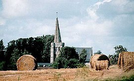 The church of Mingoval | |
 Coat of arms | |
show Location of Mingoval | |
 Mingoval | |
| Coordinates: 50°22′31″N 2°34′32″E / 50.3753°N 2.5756°ECoordinates: 50°22′31″N 2°34′32″E / 50.3753°N 2.5756°E | |
| Country | France |
| Region | Hauts-de-France |
| Department | Pas-de-Calais |
| Arrondissement | Arras |
| Canton | Avesnes-le-Comte |
| Intercommunality | CC Campagnes de l'Artois |
| Government | |
| • Mayor (2008–2014) | Jacques Deneux |
| Area 1 | 3.79 km2 (1.46 sq mi) |
| Population (Jan. 2018)[1] | 231 |
| • Density | 61/km2 (160/sq mi) |
| Time zone | UTC+01:00 (CET) |
| • Summer (DST) | UTC+02:00 (CEST) |
| INSEE/Postal code | 62574 /62690 |
| Elevation | 109–157 m (358–515 ft) (avg. 125 m or 410 ft) |
| 1 French Land Register data, which excludes lakes, ponds, glaciers > 1 km2 (0.386 sq mi or 247 acres) and river estuaries. | |


Mingoval is a commune in the Pas-de-Calais department in the Hauts-de-France region of France.
Geography[]
Mingoval is situated 12 miles (19 km) northwest of Arras, on the D73 road.
Population[]
| Year | Pop. | ±% p.a. |
|---|---|---|
| 1968 | 201 | — |
| 1975 | 196 | −0.36% |
| 1982 | 183 | −0.98% |
| 1990 | 207 | +1.55% |
| 1999 | 208 | +0.05% |
| 2007 | 202 | −0.37% |
| 2012 | 221 | +1.81% |
| 2017 | 230 | +0.80% |
| Source: INSEE[2] | ||
Places of interest[]
- The church of St.Liévin, dating from the eighteenth century.
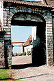
- The seventeenth century cemetery entrance.
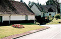
- An old farmhouse.
See also[]
References[]
- ^ "Populations légales 2018". INSEE. 28 December 2020.
- ^ Population en historique depuis 1968, INSEE
| Wikimedia Commons has media related to Mingoval. |
Ancient entrance to the old farm

The churchyard entrance

The church spire

Architectural detail
Typical regional houses

The church


This Arras arrondissement, Pas-de-Calais geographical article is a stub. You can help Wikipedia by . |
Categories:
- Communes of Pas-de-Calais
- Arras arrondissement geography stubs