Mory, Pas-de-Calais
From Wikipedia, the free encyclopedia
Commune in Hauts-de-France, France
Mory | |
|---|---|
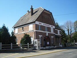 The town hall of Mory | |
 Coat of arms | |
 Mory  Mory | |
Coordinates:  50°09′25″N 2°51′12″E / 50.1569°N 2.8533°E / 50.1569; 2.8533Coordinates: 50°09′25″N 2°51′12″E / 50.1569°N 2.8533°E / 50.1569; 2.8533 50°09′25″N 2°51′12″E / 50.1569°N 2.8533°E / 50.1569; 2.8533Coordinates: 50°09′25″N 2°51′12″E / 50.1569°N 2.8533°E / 50.1569; 2.8533 | |
| Country | France |
| Region | Hauts-de-France |
| Department | Pas-de-Calais |
| Arrondissement | Arras |
| Canton | Bapaume |
| Intercommunality | CC Sud-Artois |
| Government | |
| • Mayor (2008–2014) | Joël Vasseur |
| Area 1 | 7.39 km2 (2.85 sq mi) |
| Population (Jan. 2018)[1] | 307 |
| • Density | 42/km2 (110/sq mi) |
| Time zone | UTC+01:00 (CET) |
| • Summer (DST) | UTC+02:00 (CEST) |
| INSEE/Postal code | 62594 /62159 |
| Elevation | 87–121 m (285–397 ft) (avg. 90 m or 300 ft) |
| 1 French Land Register data, which excludes lakes, ponds, glaciers > 1 km2 (0.386 sq mi or 247 acres) and river estuaries. | |

Mory is a commune in the Pas-de-Calais department in the Hauts-de-France region of France.
Geography[]
Mory is situated 13 miles (21 km) south of Arras, at the junction of the D36 and D36E roads. The A1 autoroute passes by less than a mile away
Population[]
| Year | Pop. | ±% p.a. |
|---|---|---|
| 1968 | 353 | — |
| 1975 | 315 | −1.61% |
| 1982 | 314 | −0.05% |
| 1990 | 319 | +0.20% |
| 1999 | 339 | +0.68% |
| 2007 | 342 | +0.11% |
| 2012 | 332 | −0.59% |
| 2017 | 309 | −1.43% |
| Source: INSEE[2] | ||
Places of interest[]
- The church of St.Vaast, rebuilt, as was all of the village, after World War I.
- The Commonwealth War Graves Commission cemetery.
See also[]
References[]
- ^ "Populations légales 2018". INSEE. 28 December 2020.
- ^ Population en historique depuis 1968, INSEE
External links[]
| Wikimedia Commons has media related to Mory (Pas-de-Calais). |
show
Communes of the Pas-de-Calais department | |
|---|---|
|
This Arras arrondissement, Pas-de-Calais geographical article is a stub. You can help Wikipedia by . |
- v
- t
Retrieved from ""
Categories:
- Communes of Pas-de-Calais
- Arras arrondissement geography stubs
Hidden categories:
- Articles with short description
- Short description is different from Wikidata
- Infobox mapframe without OSM relation ID on Wikidata
- Coordinates on Wikidata
- Pages using infobox settlement with image map1 but not image map
- Commons category link is on Wikidata
- Articles with BNF identifiers
- All stub articles
- Pages using the Kartographer extension