Ostreville
Ostreville | |
|---|---|
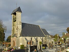 The church of Ostreville | |
 Coat of arms | |
show Location of Ostreville | |
 Ostreville | |
| Coordinates: 50°23′51″N 2°23′41″E / 50.3975°N 2.3947°ECoordinates: 50°23′51″N 2°23′41″E / 50.3975°N 2.3947°E | |
| Country | France |
| Region | Hauts-de-France |
| Department | Pas-de-Calais |
| Arrondissement | Arras |
| Canton | Saint-Pol-sur-Ternoise |
| Intercommunality | CC Ternois |
| Government | |
| • Mayor (2020–2026) | Christophe Monchy |
| Area 1 | 3.88 km2 (1.50 sq mi) |
| Population (Jan. 2018)[1] | 225 |
| • Density | 58/km2 (150/sq mi) |
| Time zone | UTC+01:00 (CET) |
| • Summer (DST) | UTC+02:00 (CEST) |
| INSEE/Postal code | 62641 /62130 |
| Elevation | 115–161 m (377–528 ft) (avg. 150 m or 490 ft) |
| 1 French Land Register data, which excludes lakes, ponds, glaciers > 1 km2 (0.386 sq mi or 247 acres) and river estuaries. | |


Ostreville (French pronunciation: [ɔstʁəvil]) is a commune in the Pas-de-Calais department in the Hauts-de-France region of France.
Geography[]
Ostreville is situated 22 miles (35 km) northwest of Arras, at the junction of the D81 and D86 roads.
Heraldry[]
 |
The arms of Ostreville are blazoned : Azure, an inescutcheon argent. (Gouzeaucourt, Saint-Jean-de-Vals, Ramburelles, Saint-Menge, Colombey-les-Belles and Ostreville use the same arms.)
|
Population[]
| Year | Pop. | ±% p.a. |
|---|---|---|
| 1968 | 244 | — |
| 1975 | 241 | −0.18% |
| 1982 | 249 | +0.47% |
| 1990 | 265 | +0.78% |
| 1999 | 276 | +0.45% |
| 2007 | 266 | −0.46% |
| 2012 | 257 | −0.69% |
| 2017 | 239 | −1.44% |
| Source: INSEE[2] | ||
Places of interest[]
- The church of St.Pierre, dating from the seventeenth century.
See also[]
References[]
- ^ "Populations légales 2018". INSEE. 28 December 2020.
- ^ Population en historique depuis 1968, INSEE
| Wikimedia Commons has media related to Ostreville. |
This Arras arrondissement, Pas-de-Calais geographical article is a stub. You can help Wikipedia by . |
Categories:
- Communes of Pas-de-Calais
- Arras arrondissement geography stubs