Reclinghem
Reclinghem
Reklingem | |
|---|---|
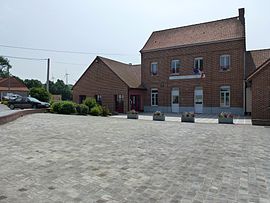 The town hall and school of Reclinghem | |
 Coat of arms | |
show Location of Reclinghem | |
 Reclinghem | |
| Coordinates: 50°34′26″N 2°10′37″E / 50.5739°N 2.1769°ECoordinates: 50°34′26″N 2°10′37″E / 50.5739°N 2.1769°E | |
| Country | France |
| Region | Hauts-de-France |
| Department | Pas-de-Calais |
| Arrondissement | Saint-Omer |
| Canton | Fruges |
| Intercommunality | Pays de Saint-Omer |
| Government | |
| • Mayor (2020–2026) | Joël Rolin |
| Area 1 | 6.05 km2 (2.34 sq mi) |
| Population (Jan. 2018)[1] | 236 |
| • Density | 39/km2 (100/sq mi) |
| Time zone | UTC+01:00 (CET) |
| • Summer (DST) | UTC+02:00 (CEST) |
| INSEE/Postal code | 62696 /62560 |
| Elevation | 54–176 m (177–577 ft) (avg. 87 m or 285 ft) |
| 1 French Land Register data, which excludes lakes, ponds, glaciers > 1 km2 (0.386 sq mi or 247 acres) and river estuaries. | |


Reclinghem (West Flemish: Reklingem) is a commune in the Pas-de-Calais department in the Hauts-de-France region of France. It was settled by the Viking Rikiwulf (the rich and powerful wolf) in the 9th century, who probably also settled nearby Richebourg and Rijkeghem in present Tielt, Belgium.[citation needed]
Geography[]
Reclinghem lies about 12 miles (19 km) south of Saint-Omer, on the D104 road, by the banks of the river Lys.
Population[]
| Year | Pop. | ±% p.a. |
|---|---|---|
| 1968 | 176 | — |
| 1975 | 135 | −3.72% |
| 1982 | 142 | +0.72% |
| 1990 | 153 | +0.94% |
| 1999 | 144 | −0.67% |
| 2007 | 175 | +2.47% |
| 2012 | 220 | +4.68% |
| 2017 | 241 | +1.84% |
| Source: INSEE[2] | ||
Places of interest[]
- The eighteenth century church of St. Firmin.
See also[]
References[]
- ^ "Populations légales 2018". INSEE. 28 December 2020.
- ^ Population en historique depuis 1968, INSEE
| Wikimedia Commons has media related to Reclinghem. |
This Pas-de-Calais geographical article is a stub. You can help Wikipedia by . |
Categories:
- Communes of Pas-de-Calais
- Pas-de-Calais geography stubs