Robecq
Robecq | |
|---|---|
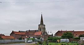 The church of Robecq | |
 Coat of arms | |
show Location of Robecq | |
 Robecq | |
| Coordinates: 50°35′48″N 2°33′51″E / 50.5967°N 2.5642°ECoordinates: 50°35′48″N 2°33′51″E / 50.5967°N 2.5642°E | |
| Country | France |
| Region | Hauts-de-France |
| Department | Pas-de-Calais |
| Arrondissement | Béthune |
| Canton | Lillers |
| Intercommunality | CA Béthune-Bruay, Artois-Lys Romane |
| Government | |
| • Mayor (2020–2026) | Hervé Deroubaix[1] |
| Area 1 | 10.56 km2 (4.08 sq mi) |
| Population (Jan. 2018)[2] | 1,351 |
| • Density | 130/km2 (330/sq mi) |
| Time zone | UTC+01:00 (CET) |
| • Summer (DST) | UTC+02:00 (CEST) |
| INSEE/Postal code | 62713 /62350 |
| Elevation | 16–20 m (52–66 ft) (avg. 19 m or 62 ft) |
| 1 French Land Register data, which excludes lakes, ponds, glaciers > 1 km2 (0.386 sq mi or 247 acres) and river estuaries. | |


Robecq is a commune in the Pas-de-Calais department in the Hauts-de-France region of France found at the junction of the D937, the D69 and the D94 roads
Geography[]
Robecq is situated about 7 miles (11.3 km) northwest of Béthune and 31 miles (49.9 km) southwest of Lille. The Canal d’Aire, the Clarence River and the Busnes river all flow through the commune.
History[]
During World War I intense action took place close to Robecq. In his posthumously published memoir, Private A S Bullock recalls the fighting at Bacquerolles Farm, noting that the German attack was repelled 'chiefly by my Lewis gun!'. He also recalls a much lighter, indeed hilarious, incident when the British troops stationed near Robecq were ordered to have a bath.[3]
Population[]
| Year | Pop. | ±% p.a. |
|---|---|---|
| 1968 | 1,109 | — |
| 1975 | 1,006 | −1.38% |
| 1982 | 1,037 | +0.43% |
| 1990 | 1,063 | +0.31% |
| 1999 | 1,062 | −0.01% |
| 2007 | 1,195 | +1.49% |
| 2012 | 1,322 | +2.04% |
| 2017 | 1,359 | +0.55% |
| Source: INSEE[4] | ||
Places of interest[]
- The church of St. Maurice, dating from the fourteenth century.
- The eighteenth-century farmhouse of L’Abiette.
- The war memorial.
- The Commonwealth War Graves Commission cemetery.
See also[]
References[]
- ^ "Répertoire national des élus: les maires". data.gouv.fr, Plateforme ouverte des données publiques françaises (in French). 2 December 2020.
- ^ "Populations légales 2018". INSEE. 28 December 2020.
- ^ Bullock, A. S., Gloucestershire Between the Wars: A Memoir, History Press, 2009, pages 69 and 72
- ^ Population en historique depuis 1968, INSEE
External links[]
| Wikimedia Commons has media related to Robecq. |
This Pas-de-Calais geographical article is a stub. You can help Wikipedia by . |
- Communes of Pas-de-Calais
- Pas-de-Calais geography stubs