Rougefay
Rougefay | |
|---|---|
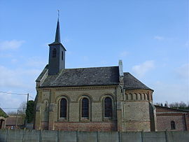 The church of Rougefay | |
 Coat of arms | |
show Location of Rougefay | |
 Rougefay | |
| Coordinates: 50°16′26″N 2°10′20″E / 50.2739°N 2.1722°ECoordinates: 50°16′26″N 2°10′20″E / 50.2739°N 2.1722°E | |
| Country | France |
| Region | Hauts-de-France |
| Department | Pas-de-Calais |
| Arrondissement | Arras |
| Canton | Auxi-le-Château |
| Intercommunality | CC Ternois |
| Government | |
| • Mayor (2020–2026) | Olivier Huchette[1] |
| Area 1 | 3.86 km2 (1.49 sq mi) |
| Population (Jan. 2018)[2] | 87 |
| • Density | 23/km2 (58/sq mi) |
| Time zone | UTC+01:00 (CET) |
| • Summer (DST) | UTC+02:00 (CEST) |
| INSEE/Postal code | 62722 /62390 |
| Elevation | 104–142 m (341–466 ft) (avg. 110 m or 360 ft) |
| 1 French Land Register data, which excludes lakes, ponds, glaciers > 1 km2 (0.386 sq mi or 247 acres) and river estuaries. | |


Rougefay is a commune in the Pas-de-Calais department in the Hauts-de-France region of France.
Geography[]
Rougefay lies about 32 miles (51 km) west of Arras, at the junction of the D110 and D102 roads.
Surrounded by the communes Buire-au-Bois, Haravesnes and Boffles, Rougefay is located 30 km north-east of Abbeville, the largest city nearby.[3]
Population[]
| Year | Pop. | ±% p.a. |
|---|---|---|
| 1968 | 173 | — |
| 1975 | 171 | −0.17% |
| 1982 | 147 | −2.14% |
| 1990 | 130 | −1.52% |
| 1999 | 115 | −1.35% |
| 2007 | 103 | −1.37% |
| 2012 | 89 | −2.88% |
| 2017 | 86 | −0.68% |
| Source: INSEE[4] | ||
Places of interest[]
- The nineteenth century church.
- Saint-Anne's chapel.
See also[]
References[]
- ^ "Répertoire national des élus: les maires". data.gouv.fr, Plateforme ouverte des données publiques françaises (in French). 2 December 2020.
- ^ "Populations légales 2018". INSEE. 28 December 2020.
- ^ "Annuaire-Mairie"
- ^ Population en historique depuis 1968, INSEE
| Wikimedia Commons has media related to Rougefay. |
This Arras arrondissement, Pas-de-Calais geographical article is a stub. You can help Wikipedia by . |
Categories:
- Communes of Pas-de-Calais
- Arras arrondissement geography stubs