Saudemont
From Wikipedia, the free encyclopedia
Commune in Hauts-de-France, France
Saudemont | |
|---|---|
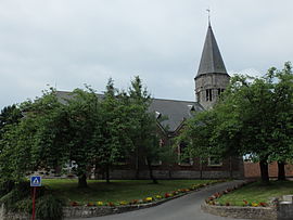 The church of Saudemont | |
 Coat of arms | |
 Saudemont  Saudemont | |
Coordinates:  50°14′41″N 3°02′27″E / 50.2447°N 3.0408°E / 50.2447; 3.0408Coordinates: 50°14′41″N 3°02′27″E / 50.2447°N 3.0408°E / 50.2447; 3.0408 50°14′41″N 3°02′27″E / 50.2447°N 3.0408°E / 50.2447; 3.0408Coordinates: 50°14′41″N 3°02′27″E / 50.2447°N 3.0408°E / 50.2447; 3.0408 | |
| Country | France |
| Region | Hauts-de-France |
| Department | Pas-de-Calais |
| Arrondissement | Arras |
| Canton | Brebières |
| Intercommunality | CC Osartis Marquion |
| Government | |
| • Mayor (2008–2014) | Jean-Pierre Cuvilliez |
| Area 1 | 5.55 km2 (2.14 sq mi) |
| Population (Jan. 2018)[1] | 444 |
| • Density | 80/km2 (210/sq mi) |
| Time zone | UTC+01:00 (CET) |
| • Summer (DST) | UTC+02:00 (CEST) |
| INSEE/Postal code | 62782 /62860 |
| Elevation | 39–75 m (128–246 ft) (avg. 48 m or 157 ft) |
| 1 French Land Register data, which excludes lakes, ponds, glaciers > 1 km2 (0.386 sq mi or 247 acres) and river estuaries. | |

Saudemont is a commune in the Pas-de-Calais department in the Hauts-de-France region of France.
Geography[]
Saudemont lies 14 miles (22.5 km) southeast of Arras, at the junction of the D39 and D13 roads. The A26 autoroute passes by at a distance of half a mile.
Population[]
| Year | Pop. | ±% p.a. |
|---|---|---|
| 1968 | 315 | — |
| 1975 | 300 | −0.69% |
| 1982 | 374 | +3.20% |
| 1990 | 382 | +0.26% |
| 1999 | 375 | −0.21% |
| 2007 | 432 | +1.78% |
| 2012 | 452 | +0.91% |
| 2017 | 449 | −0.13% |
| Source: INSEE[2] | ||
Places of interest[]
- The church of St.Léger, dating from the twelfth century.
See also[]
Communes of the Pas-de-Calais department
References[]
- ^ "Populations légales 2018". INSEE. 28 December 2020.
- ^ Population en historique depuis 1968, INSEE
External links[]
| Wikimedia Commons has media related to Saudemont. |
show
Communes of the Pas-de-Calais department | |
|---|---|
|
This Arras arrondissement, Pas-de-Calais geographical article is a stub. You can help Wikipedia by . |
- v
- t
Retrieved from ""
Categories:
- Communes of Pas-de-Calais
- Arras arrondissement geography stubs
Hidden categories:
- Articles with short description
- Short description is different from Wikidata
- Infobox mapframe without OSM relation ID on Wikidata
- Coordinates on Wikidata
- Pages using infobox settlement with image map1 but not image map
- Commons category link from Wikidata
- Articles with BNF identifiers
- All stub articles
- Pages using the Kartographer extension