Seninghem
From Wikipedia, the free encyclopedia
Commune in Hauts-de-France, France
Seninghem | |
|---|---|
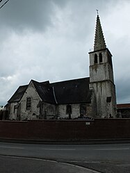 The church of Seninghem | |
 Coat of arms | |
 Seninghem  Seninghem | |
Coordinates:  50°42′12″N 2°02′05″E / 50.7033°N 2.0347°E / 50.7033; 2.0347Coordinates: 50°42′12″N 2°02′05″E / 50.7033°N 2.0347°E / 50.7033; 2.0347 50°42′12″N 2°02′05″E / 50.7033°N 2.0347°E / 50.7033; 2.0347Coordinates: 50°42′12″N 2°02′05″E / 50.7033°N 2.0347°E / 50.7033; 2.0347 | |
| Country | France |
| Region | Hauts-de-France |
| Department | Pas-de-Calais |
| Arrondissement | Saint-Omer |
| Canton | Lumbres |
| Intercommunality | Pays de Lumbres |
| Government | |
| • Mayor (2020–2026) | Christian Tellier |
| Area 1 | 15.15 km2 (5.85 sq mi) |
| Population (Jan. 2018)[1] | 708 |
| • Density | 47/km2 (120/sq mi) |
| Time zone | UTC+01:00 (CET) |
| • Summer (DST) | UTC+02:00 (CEST) |
| INSEE/Postal code | 62788 /62380 |
| Elevation | 65–209 m (213–686 ft) (avg. 150 m or 490 ft) |
| 1 French Land Register data, which excludes lakes, ponds, glaciers > 1 km2 (0.386 sq mi or 247 acres) and river estuaries. | |

Seninghem is a commune in the Pas-de-Calais department in the Hauts-de-France region of France.
Geography[]
Seninghem is located some 10 miles (16 km) west of Saint-Omer, on the D204 road.
Population[]
| Year | Pop. | ±% p.a. |
|---|---|---|
| 1968 | 455 | — |
| 1975 | 467 | +0.37% |
| 1982 | 445 | −0.69% |
| 1990 | 508 | +1.67% |
| 1999 | 519 | +0.24% |
| 2007 | 584 | +1.49% |
| 2012 | 674 | +2.91% |
| 2017 | 722 | +1.39% |
| Source: INSEE[2] | ||
Places of interest[]
- The church of St.Martin, dating from the seventeenth century.
- The seventeenth century chapel of Notre-Dame.
- The ‘Arcs de Triomphe’ at the cemetery entrances.
See also[]
Communes of the Pas-de-Calais department
References[]
- ^ "Populations légales 2018". INSEE. 28 December 2020.
- ^ Population en historique depuis 1968, INSEE
External links[]
| Wikimedia Commons has media related to Seninghem. |
- Seninghem on the Quid website (in French)
show
Communes of the Pas-de-Calais department | |
|---|---|
|
This Pas-de-Calais geographical article is a stub. You can help Wikipedia by . |
- v
- t
Retrieved from ""
Categories:
- Communes of Pas-de-Calais
- Pas-de-Calais geography stubs
Hidden categories:
- Articles with short description
- Short description is different from Wikidata
- Coordinates on Wikidata
- Pages using infobox settlement with image map1 but not image map
- Commons category link from Wikidata
- Articles with French-language sources (fr)
- Articles with BNF identifiers
- All stub articles
- Pages using the Kartographer extension