Thiembronne
From Wikipedia, the free encyclopedia
Commune in Hauts-de-France, France
Thiembronne
Teenbronne | |
|---|---|
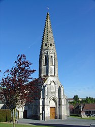 The church of Thiembronne | |
 Coat of arms | |
 Thiembronne  Thiembronne | |
Coordinates:  50°37′16″N 2°03′30″E / 50.6211°N 2.0583°E / 50.6211; 2.0583Coordinates: 50°37′16″N 2°03′30″E / 50.6211°N 2.0583°E / 50.6211; 2.0583 50°37′16″N 2°03′30″E / 50.6211°N 2.0583°E / 50.6211; 2.0583Coordinates: 50°37′16″N 2°03′30″E / 50.6211°N 2.0583°E / 50.6211; 2.0583 | |
| Country | France |
| Region | Hauts-de-France |
| Department | Pas-de-Calais |
| Arrondissement | Saint-Omer |
| Canton | Fruges |
| Intercommunality | Pays de Saint-Omer |
| Government | |
| • Mayor (2020–2026) | Didier Dewamin |
| Area 1 | 22.82 km2 (8.81 sq mi) |
| Population (Jan. 2018)[1] | 819 |
| • Density | 36/km2 (93/sq mi) |
| Time zone | UTC+01:00 (CET) |
| • Summer (DST) | UTC+02:00 (CEST) |
| INSEE/Postal code | 62812 /62560 |
| Elevation | 76–201 m (249–659 ft) (avg. 160 m or 520 ft) |
| 1 French Land Register data, which excludes lakes, ponds, glaciers > 1 km2 (0.386 sq mi or 247 acres) and river estuaries. | |

Thiembronne (West Flemish: Teenbronne) is a commune in the Pas-de-Calais department in the Hauts-de-France region of France.
Geography[]
Thiembronne is located 15 miles (24 km) southwest of Saint-Omer, on the D158 and D132 road junction.
Population[]
| Year | Pop. | ±% p.a. |
|---|---|---|
| 1968 | 694 | — |
| 1975 | 645 | −1.04% |
| 1982 | 621 | −0.54% |
| 1990 | 597 | −0.49% |
| 1999 | 621 | +0.44% |
| 2007 | 687 | +1.27% |
| 2012 | 808 | +3.30% |
| 2017 | 834 | +0.64% |
| Source: INSEE[2] | ||
Places of interest[]
- The church of Saint Pierre, dating from the nineteenth century.
- The nineteenth-century château.
- The remains of the medieval château, destroyed in 1595.
See also[]
References[]
- ^ "Populations légales 2018". INSEE. 28 December 2020.
- ^ Population en historique depuis 1968, INSEE
| Wikimedia Commons has media related to Thiembronne. |
show
Communes of the Pas-de-Calais department | |
|---|---|
|
This Pas-de-Calais geographical article is a stub. You can help Wikipedia by . |
- v
- t
Retrieved from ""
Categories:
- Communes of Pas-de-Calais
- Pas-de-Calais geography stubs
Hidden categories:
- Articles with short description
- Short description is different from Wikidata
- Coordinates on Wikidata
- Pages using infobox settlement with image map1 but not image map
- Articles containing West Flemish-language text
- Commons category link from Wikidata
- Articles with BNF identifiers
- All stub articles
- Pages using the Kartographer extension