Verchin
From Wikipedia, the free encyclopedia
Commune in Hauts-de-France, France
Verchin | |
|---|---|
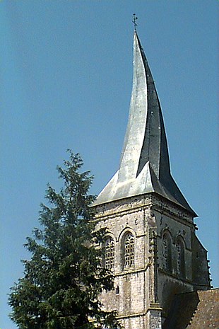
 The church of Verchin | |
 Coat of arms | |
 Verchin  Verchin | |
Coordinates:  50°29′43″N 2°11′07″E / 50.4953°N 2.1853°E / 50.4953; 2.1853Coordinates: 50°29′43″N 2°11′07″E / 50.4953°N 2.1853°E / 50.4953; 2.1853 50°29′43″N 2°11′07″E / 50.4953°N 2.1853°E / 50.4953; 2.1853Coordinates: 50°29′43″N 2°11′07″E / 50.4953°N 2.1853°E / 50.4953; 2.1853 | |
| Country | France |
| Region | Hauts-de-France |
| Department | Pas-de-Calais |
| Arrondissement | Montreuil |
| Canton | Fruges |
| Intercommunality | CC Haut Pays du Montreuillois |
| Government | |
| • Mayor (2008–2014) | Gilles De Lencquesaing |
| Area 1 | 10.68 km2 (4.12 sq mi) |
| Population (Jan. 2018)[1] | 238 |
| • Density | 22/km2 (58/sq mi) |
| Time zone | UTC+01:00 (CET) |
| • Summer (DST) | UTC+02:00 (CEST) |
| INSEE/Postal code | 62843 /62310 |
| Elevation | 88–171 m (289–561 ft) (avg. 102 m or 335 ft) |
| 1 French Land Register data, which excludes lakes, ponds, glaciers > 1 km2 (0.386 sq mi or 247 acres) and river estuaries. | |

Verchin is a commune in the Pas-de-Calais department in the Hauts-de-France region of France.
Geography[]
Verchin is located 20 miles (32 km) east of Montreuil-sur-Mer on the D93 road.
Population[]
The inhabitants are called Verchinois.
| Year | 1962 | 1968 | 1975 | 1982 | 1990 | 1999 | 2006 |
|---|---|---|---|---|---|---|---|
| Population | 302 | 303 | 276 | 250 | 220 | 220 | 194 |
| From the year 1962 on: No double counting—residents of multiple communes (e.g. students and military personnel) are counted only once. | |||||||
Places of interest[]
- The Château, dating from the sixteenth century
- The seventeenth century presbytery.
- The flamboyant gothic church of St. Omer, dating from the seventeenth century, with its twisted spire, caused by the use of unseasoned timber.
See also[]
References[]
- ^ "Populations légales 2018". INSEE. 28 December 2020.
| Wikimedia Commons has media related to Verchin. |
show
Communes of the Pas-de-Calais department | |
|---|---|
|
| show Authority control | |
|---|---|
| General |
|
| National libraries | |
This Pas-de-Calais geographical article is a stub. You can help Wikipedia by . |
- v
- t
Retrieved from ""
Categories:
- Communes of Pas-de-Calais
- Pas-de-Calais geography stubs
Hidden categories:
- Articles with short description
- Short description is different from Wikidata
- Coordinates on Wikidata
- Pages using infobox settlement with image map1 but not image map
- Commons category link from Wikidata
- Articles with VIAF identifiers
- Articles with BNF identifiers
- Articles with WorldCat-VIAF identifiers
- All stub articles
- Pages using the Kartographer extension