Warlencourt-Eaucourt
Warlencourt-Eaucourt | |
|---|---|
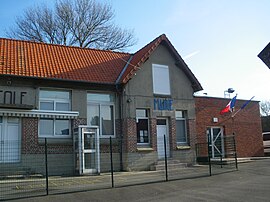
 The town hall of Warlencourt-Eaucourt | |
 Coat of arms | |
show Location of Warlencourt-Eaucourt | |
 Warlencourt-Eaucourt | |
| Coordinates: 50°05′00″N 2°47′27″E / 50.0833°N 2.7908°ECoordinates: 50°05′00″N 2°47′27″E / 50.0833°N 2.7908°E | |
| Country | France |
| Region | Hauts-de-France |
| Department | Pas-de-Calais |
| Arrondissement | Arras |
| Canton | Bapaume |
| Intercommunality | Sud-Artois |
| Government | |
| • Mayor (2014-2020) | Lucien Guise |
| Area 1 | 3.71 km2 (1.43 sq mi) |
| Population (Jan. 2018)[1] | 136 |
| • Density | 37/km2 (95/sq mi) |
| Time zone | UTC+01:00 (CET) |
| • Summer (DST) | UTC+02:00 (CEST) |
| INSEE/Postal code | 62876 /62450 |
| Elevation | 92–128 m (302–420 ft) (avg. 106 m or 348 ft) |
| 1 French Land Register data, which excludes lakes, ponds, glaciers > 1 km2 (0.386 sq mi or 247 acres) and river estuaries. | |
Warlencourt-Eaucourt is a commune in the Pas-de-Calais department in the Hauts-de-France region of France.
Geography[]
Warlencourt-Eaucourt is situated some 16 miles (25.7 km) south of Arras, at the junction of the D929 and the D10E roads.
Population[]
| Year | Pop. | ±% |
|---|---|---|
| 2006 | 139 | — |
| 2007 | 146 | +5.0% |
| 2008 | 151 | +3.4% |
| 2009 | 157 | +4.0% |
| 2010 | 162 | +3.2% |
| 2011 | 166 | +2.5% |
| 2012 | 167 | +0.6% |
| 2013 | 160 | −4.2% |
| 2014 | 153 | −4.4% |
| 2015 | 146 | −4.6% |
| 2016 | 143 | −2.1% |
Places of interest[]
- The church of St. Pierre, rebuilt, along with the rest of the village, after World War I.
- The Warlencourt British Cemetery, in which over 3,000 soldiers who died during World War I are buried.
- The war memorials:
See also[]
References[]
- ^ "Populations légales 2018". INSEE. 28 December 2020.
- ^ Jump up to: a b The war memorials of Warlencourt-Eaucourt. MÉMOIRES DE PIERRE (in French)
External links[]
| Wikimedia Commons has media related to Warlencourt-Eaucourt. |
Categories:
- Communes of Pas-de-Calais
- Arras arrondissement geography stubs


